You are here: Home > Network List > GS - US Geological Survey Networks Stations List
> Station KAN11 Stewart Ranch, Harper County, KS, USA > Earthquake Result Viewer
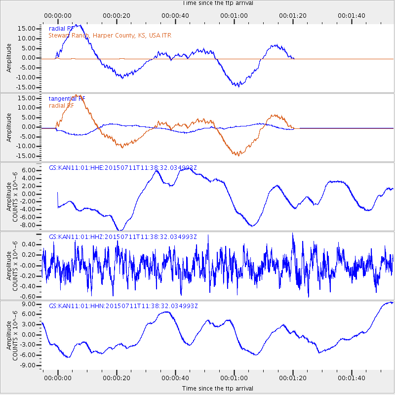
KAN11 Stewart Ranch, Harper County, KS, USA - Earthquake Result Viewer
*The percent match for this event was below the threshold and hence no stack was calculated.
| Earthquake location: |
East Of Kuril Islands |
| Earthquake latitude/longitude: |
43.9/148.0 |
| Earthquake time(UTC): |
2015/07/11 (192) 11:26:59 GMT |
| Earthquake Depth: |
32 km |
| Earthquake Magnitude: |
5.5 MB |
| Earthquake Catalog/Contributor: |
NEIC PDE/NEIC COMCAT |
|
| Network: |
GS US Geological Survey Networks |
| Station: |
KAN11 Stewart Ranch, Harper County, KS, USA |
| Lat/Lon: |
37.21 N/97.91 W |
| Elevation: |
410 m |
|
| Distance: |
79.6 deg |
| Az: |
47.838 deg |
| Baz: |
317.847 deg |
| Ray Param: |
$rayparam |
*The percent match for this event was below the threshold and hence was not used in the summary stack. |
|
| Radial Match: |
41.893692 % |
| Radial Bump: |
400 |
| Transverse Match: |
53.605743 % |
| Transverse Bump: |
400 |
| SOD ConfigId: |
1085051 |
| Insert Time: |
2015-07-25 12:07:29.358 +0000 |
| GWidth: |
2.5 |
| Max Bumps: |
400 |
| Tol: |
0.001 |
|
Signal To Noise
| Channel | StoN | STA | LTA |
| GS:KAN11:01:HHZ:20150711T11:38:32.034993Z | 0.7872121 | 1.5436873E-7 | 1.9609547E-7 |
| GS:KAN11:01:HHN:20150711T11:38:32.034993Z | 7.8197894 | 1.1059964E-5 | 1.4143557E-6 |
| GS:KAN11:01:HHE:20150711T11:38:32.034993Z | 4.1761365 | 8.886822E-6 | 2.128001E-6 |
| Arrivals |
| Ps | |
| PpPs | |
| PsPs/PpSs | |


