You are here: Home > Network List > IU - Global Seismograph Network (GSN - IRIS/USGS) Stations List
> Station CTAO Charters Towers, Australia > Earthquake Result Viewer
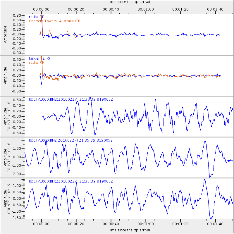
CTAO Charters Towers, Australia - Earthquake Result Viewer
*The percent match for this event was below the threshold and hence no stack was calculated.
| Earthquake location: |
Western Indian-Antarctic Ridge |
| Earthquake latitude/longitude: |
-51.8/139.6 |
| Earthquake time(UTC): |
2016/02/27 (058) 21:29:43 GMT |
| Earthquake Depth: |
10 km |
| Earthquake Magnitude: |
5.9 MB, 6.1 MWB, 6.2 MWW |
| Earthquake Catalog/Contributor: |
NEIC PDE/NEIC COMCAT |
|
| Network: |
IU Global Seismograph Network (GSN - IRIS/USGS) |
| Station: |
CTAO Charters Towers, Australia |
| Lat/Lon: |
20.09 S/146.25 E |
| Elevation: |
357 m |
|
| Distance: |
32.1 deg |
| Az: |
11.914 deg |
| Baz: |
187.842 deg |
| Ray Param: |
$rayparam |
*The percent match for this event was below the threshold and hence was not used in the summary stack. |
|
| Radial Match: |
78.854866 % |
| Radial Bump: |
400 |
| Transverse Match: |
58.944164 % |
| Transverse Bump: |
400 |
| SOD ConfigId: |
7422571 |
| Insert Time: |
2019-04-21 23:43:13.583 +0000 |
| GWidth: |
2.5 |
| Max Bumps: |
400 |
| Tol: |
0.001 |
|
Signal To Noise
| Channel | StoN | STA | LTA |
| IU:CTAO:00:BHZ:20160227T21:35:39.819005Z | 2.0062716 | 9.3901457E-7 | 4.680396E-7 |
| IU:CTAO:00:BH1:20160227T21:35:39.819005Z | 1.1445348 | 4.852042E-7 | 4.2393137E-7 |
| IU:CTAO:00:BH2:20160227T21:35:39.819005Z | 1.4584928 | 3.629429E-7 | 2.4884793E-7 |
| Arrivals |
| Ps | |
| PpPs | |
| PsPs/PpSs | |


