You are here: Home > Network List > KN - Kyrgyz Seismic Telemetry Network Stations List
> Station TKM2 - > Earthquake Result Viewer
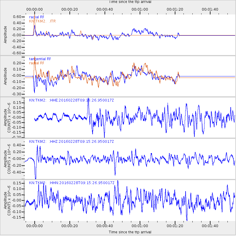
TKM2 - - Earthquake Result Viewer
*The percent match for this event was below the threshold and hence no stack was calculated.
| Earthquake location: |
Mindanao, Philippines |
| Earthquake latitude/longitude: |
5.3/125.3 |
| Earthquake time(UTC): |
2016/02/28 (059) 09:06:25 GMT |
| Earthquake Depth: |
178 km |
| Earthquake Magnitude: |
5.5 MWW |
| Earthquake Catalog/Contributor: |
NEIC PDE/NEIC COMCAT |
|
| Network: |
KN Kyrgyz Seismic Telemetry Network |
| Station: |
TKM2 - |
| Lat/Lon: |
42.92 N/75.60 E |
| Elevation: |
2020 m |
|
| Distance: |
57.7 deg |
| Az: |
318.443 deg |
| Baz: |
115.937 deg |
| Ray Param: |
$rayparam |
*The percent match for this event was below the threshold and hence was not used in the summary stack. |
|
| Radial Match: |
66.01485 % |
| Radial Bump: |
400 |
| Transverse Match: |
59.768272 % |
| Transverse Bump: |
400 |
| SOD ConfigId: |
7422571 |
| Insert Time: |
2019-04-21 23:46:20.770 +0000 |
| GWidth: |
2.5 |
| Max Bumps: |
400 |
| Tol: |
0.001 |
|
Signal To Noise
| Channel | StoN | STA | LTA |
| KN:TKM2: :HHZ:20160228T09:15:26.950017Z | 5.9395185 | 2.4446973E-7 | 4.1159858E-8 |
| KN:TKM2: :HHN:20160228T09:15:26.950017Z | 1.3717309 | 5.4153737E-8 | 3.9478397E-8 |
| KN:TKM2: :HHE:20160228T09:15:26.950017Z | 3.8325462 | 8.468192E-8 | 2.2095472E-8 |
| Arrivals |
| Ps | |
| PpPs | |
| PsPs/PpSs | |


