You are here: Home > Network List > IC - New China Digital Seismograph Network Stations List
> Station WMQ Urumqi, Xinjiang Province, China > Earthquake Result Viewer
WMQ Urumqi, Xinjiang Province, China - Earthquake Result Viewer

| Earthquake location: |
Solomon Islands |
| Earthquake latitude/longitude: |
-6.6/155.0 |
| Earthquake time(UTC): |
1996/05/11 (132) 13:43:45 GMT |
| Earthquake Depth: |
33 km |
| Earthquake Magnitude: |
5.7 MB, 6.3 MS, 6.4 UNKNOWN, 6.3 MW |
| Earthquake Catalog/Contributor: |
WHDF/NEIC |
|
| Network: |
IC New China Digital Seismograph Network |
| Station: |
WMQ Urumqi, Xinjiang Province, China |
| Lat/Lon: |
43.82 N/87.69 E |
| Elevation: |
903 m |
|
| Distance: |
78.6 deg |
| Az: |
317.041 deg |
| Baz: |
110.718 deg |
| Ray Param: |
0.04950562 |
| Estimated Moho Depth: |
46.25 km |
| Estimated Crust Vp/Vs: |
1.80 |
| Assumed Crust Vp: |
6.242 km/s |
| Estimated Crust Vs: |
3.477 km/s |
| Estimated Crust Poisson's Ratio: |
0.27 |
|
| Radial Match: |
94.57841 % |
| Radial Bump: |
400 |
| Transverse Match: |
80.1468 % |
| Transverse Bump: |
400 |
| SOD ConfigId: |
6273 |
| Insert Time: |
2010-03-05 00:13:40.354 +0000 |
| GWidth: |
2.5 |
| Max Bumps: |
400 |
| Tol: |
0.001 |
|
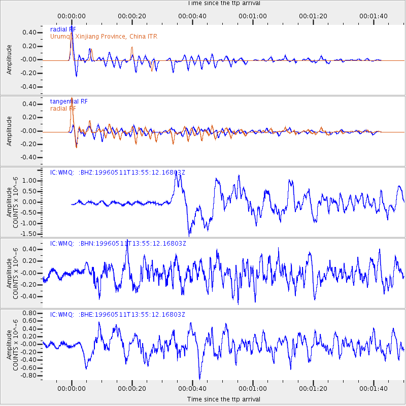
Signal To Noise
| Channel | StoN | STA | LTA |
| IC:WMQ: :BHN:19960511T13:55:12.16803Z | 1.101086 | 6.383934E-8 | 5.797852E-8 |
| IC:WMQ: :BHE:19960511T13:55:12.16803Z | 3.786305 | 1.9263891E-7 | 5.087781E-8 |
| IC:WMQ: :BHZ:19960511T13:55:12.16803Z | 8.614593 | 5.0050437E-7 | 5.8099598E-8 |
| Arrivals |
| Ps | 6.1 SECOND |
| PpPs | 20 SECOND |
| PsPs/PpSs | 26 SECOND |


