You are here: Home > Network List > CI - Caltech Regional Seismic Network Stations List
> Station IRM Iron Mountain Pumping Station, Eagle Mtn., CA, USA > Earthquake Result Viewer
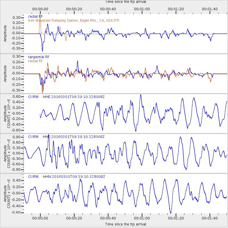
IRM Iron Mountain Pumping Station, Eagle Mtn., CA, USA - Earthquake Result Viewer
*The percent match for this event was below the threshold and hence no stack was calculated.
| Earthquake location: |
South Of Kermadec Islands |
| Earthquake latitude/longitude: |
-32.9/-178.4 |
| Earthquake time(UTC): |
2016/03/01 (061) 09:26:45 GMT |
| Earthquake Depth: |
10 km |
| Earthquake Magnitude: |
5.6 MWW, 5.5 MWB, 5.7 MWC |
| Earthquake Catalog/Contributor: |
NEIC PDE/NEIC COMCAT |
|
| Network: |
CI Caltech Regional Seismic Network |
| Station: |
IRM Iron Mountain Pumping Station, Eagle Mtn., CA, USA |
| Lat/Lon: |
34.16 N/115.15 W |
| Elevation: |
567 m |
|
| Distance: |
89.3 deg |
| Az: |
47.773 deg |
| Baz: |
228.67 deg |
| Ray Param: |
$rayparam |
*The percent match for this event was below the threshold and hence was not used in the summary stack. |
|
| Radial Match: |
72.88549 % |
| Radial Bump: |
333 |
| Transverse Match: |
74.34854 % |
| Transverse Bump: |
400 |
| SOD ConfigId: |
7422571 |
| Insert Time: |
2019-04-21 23:50:13.764 +0000 |
| GWidth: |
2.5 |
| Max Bumps: |
400 |
| Tol: |
0.001 |
|
Signal To Noise
| Channel | StoN | STA | LTA |
| CI:IRM: :HHZ:20160301T09:39:10.328008Z | 2.343059 | 4.6200998E-7 | 1.9718239E-7 |
| CI:IRM: :HHN:20160301T09:39:10.328008Z | 0.79984206 | 1.16793935E-7 | 1.4602124E-7 |
| CI:IRM: :HHE:20160301T09:39:10.328008Z | 1.513379 | 2.8653093E-7 | 1.8933191E-7 |
| Arrivals |
| Ps | |
| PpPs | |
| PsPs/PpSs | |


