You are here: Home > Network List > IC - New China Digital Seismograph Network Stations List
> Station WMQ Urumqi, Xinjiang Province, China > Earthquake Result Viewer
WMQ Urumqi, Xinjiang Province, China - Earthquake Result Viewer
| Earthquake location: |
Kuril Islands |
| Earthquake latitude/longitude: |
45.3/149.9 |
| Earthquake time(UTC): |
1996/02/07 (038) 21:36:45 GMT |
| Earthquake Depth: |
33 km |
| Earthquake Magnitude: |
6.3 MB, 7.0 MS, 7.2 UNKNOWN, 7.1 MW |
| Earthquake Catalog/Contributor: |
WHDF/NEIC |
|
| Network: |
IC New China Digital Seismograph Network |
| Station: |
WMQ Urumqi, Xinjiang Province, China |
| Lat/Lon: |
43.82 N/87.69 E |
| Elevation: |
903 m |
|
| Distance: |
43.4 deg |
| Az: |
291.144 deg |
| Baz: |
65.379 deg |
| Ray Param: |
0.072534725 |
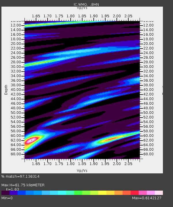
| Estimated Moho Depth: |
61.75 km |
| Estimated Crust Vp/Vs: |
1.63 |
| Assumed Crust Vp: |
6.242 km/s |
| Estimated Crust Vs: |
3.829 km/s |
| Estimated Crust Poisson's Ratio: |
0.20 |
|
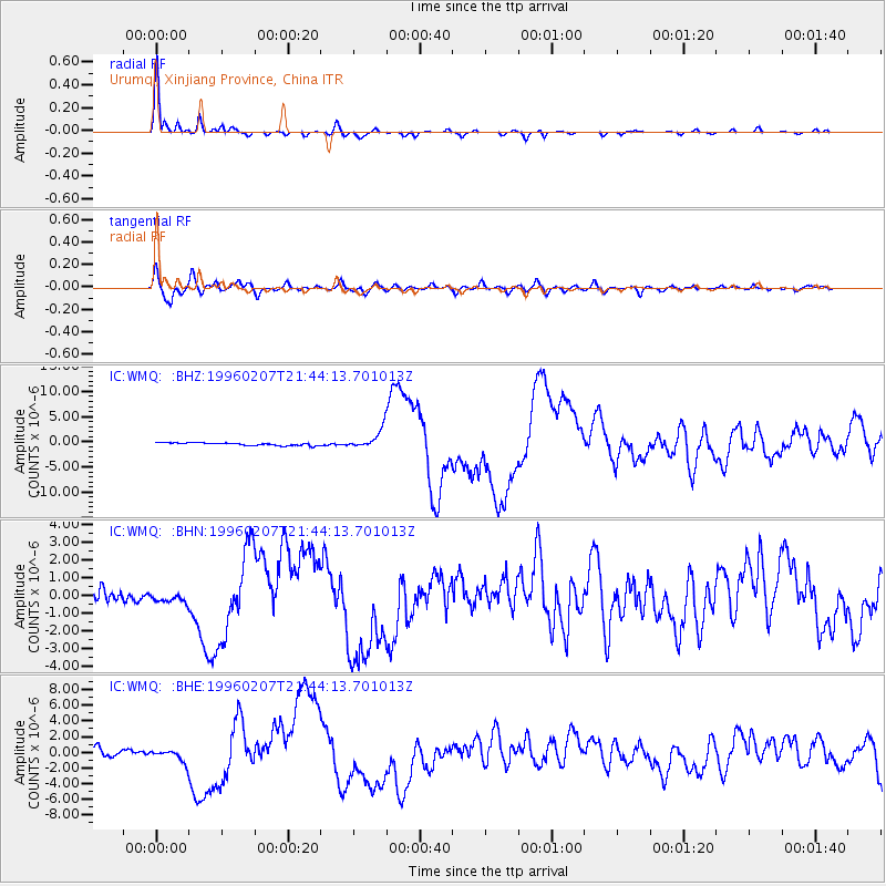
| Radial Match: |
97.136314 % |
| Radial Bump: |
254 |
| Transverse Match: |
82.014275 % |
| Transverse Bump: |
400 |
| SOD ConfigId: |
6273 |
| Insert Time: |
2010-03-05 00:13:49.708 +0000 |
| GWidth: |
2.5 |
| Max Bumps: |
400 |
| Tol: |
0.001 |
|
Signal To Noise
| Channel | StoN | STA | LTA |
| IC:WMQ: :BHN:19960207T21:44:13.701013Z | 1.1762447 | 2.8172138E-7 | 2.3950915E-7 |
| IC:WMQ: :BHE:19960207T21:44:13.701013Z | 2.3477044 | 7.650632E-7 | 3.2587715E-7 |
| IC:WMQ: :BHZ:19960207T21:44:13.701013Z | 7.091369 | 1.8828821E-6 | 2.6551743E-7 |
| Arrivals |
| Ps | 6.7 SECOND |
| PpPs | 24 SECOND |
| PsPs/PpSs | 31 SECOND |


