You are here: Home > Network List > TA - USArray Transportable Network (new EarthScope stations) Stations List
> Station M22K Willow, AK, USA > Earthquake Result Viewer
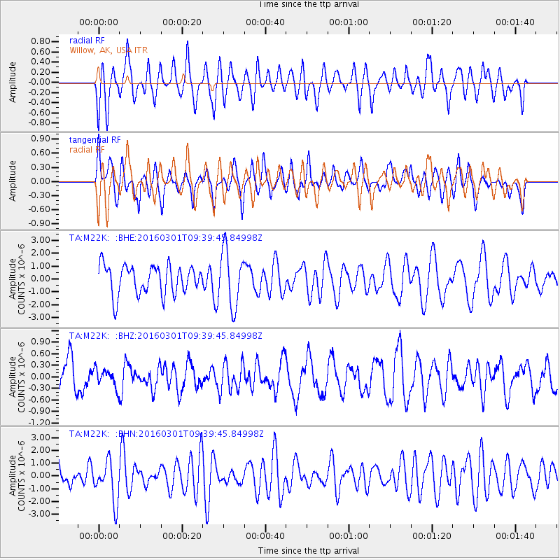
M22K Willow, AK, USA - Earthquake Result Viewer
*The percent match for this event was below the threshold and hence no stack was calculated.
| Earthquake location: |
South Of Kermadec Islands |
| Earthquake latitude/longitude: |
-32.9/-178.4 |
| Earthquake time(UTC): |
2016/03/01 (061) 09:26:45 GMT |
| Earthquake Depth: |
10 km |
| Earthquake Magnitude: |
5.6 MWW, 5.5 MWB, 5.7 MWC |
| Earthquake Catalog/Contributor: |
NEIC PDE/NEIC COMCAT |
|
| Network: |
TA USArray Transportable Network (new EarthScope stations) |
| Station: |
M22K Willow, AK, USA |
| Lat/Lon: |
61.75 N/150.12 W |
| Elevation: |
57 m |
|
| Distance: |
97.1 deg |
| Az: |
13.122 deg |
| Baz: |
203.66 deg |
| Ray Param: |
$rayparam |
*The percent match for this event was below the threshold and hence was not used in the summary stack. |
|
| Radial Match: |
48.64284 % |
| Radial Bump: |
400 |
| Transverse Match: |
39.492477 % |
| Transverse Bump: |
352 |
| SOD ConfigId: |
7422571 |
| Insert Time: |
2019-04-21 23:52:26.011 +0000 |
| GWidth: |
2.5 |
| Max Bumps: |
400 |
| Tol: |
0.001 |
|
Signal To Noise
| Channel | StoN | STA | LTA |
| TA:M22K: :BHZ:20160301T09:39:45.84998Z | 0.5304433 | 2.4182663E-7 | 4.558953E-7 |
| TA:M22K: :BHN:20160301T09:39:45.84998Z | 1.5762414 | 1.6369031E-6 | 1.038485E-6 |
| TA:M22K: :BHE:20160301T09:39:45.84998Z | 1.976034 | 2.2118832E-6 | 1.1193547E-6 |
| Arrivals |
| Ps | |
| PpPs | |
| PsPs/PpSs | |


