You are here: Home > Network List > CB - China National Seismic Network Stations List
> Station LYN Luoyang,Henan Province > Earthquake Result Viewer
LYN Luoyang,Henan Province - Earthquake Result Viewer
| Earthquake location: |
Southwest Of Sumatra, Indonesia |
| Earthquake latitude/longitude: |
-4.9/94.2 |
| Earthquake time(UTC): |
2016/03/02 (062) 12:49:46 GMT |
| Earthquake Depth: |
10 km |
| Earthquake Magnitude: |
7.9 MWW |
| Earthquake Catalog/Contributor: |
NEIC PDE/NEIC COMCAT |
|
| Network: |
CB China National Seismic Network |
| Station: |
LYN Luoyang,Henan Province |
| Lat/Lon: |
34.55 N/112.47 E |
| Elevation: |
170 m |
|
| Distance: |
42.8 deg |
| Az: |
22.321 deg |
| Baz: |
207.288 deg |
| Ray Param: |
0.07292867 |
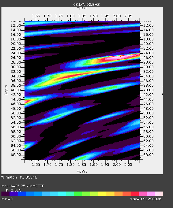
| Estimated Moho Depth: |
25.25 km |
| Estimated Crust Vp/Vs: |
2.02 |
| Assumed Crust Vp: |
6.155 km/s |
| Estimated Crust Vs: |
3.055 km/s |
| Estimated Crust Poisson's Ratio: |
0.34 |
|
| Radial Match: |
91.85346 % |
| Radial Bump: |
291 |
| Transverse Match: |
77.68012 % |
| Transverse Bump: |
400 |
| SOD ConfigId: |
7422571 |
| Insert Time: |
2019-04-21 23:54:37.244 +0000 |
| GWidth: |
2.5 |
| Max Bumps: |
400 |
| Tol: |
0.001 |
|

Signal To Noise
| Channel | StoN | STA | LTA |
| CB:LYN:00:BHZ:20160302T12:57:13.529989Z | 10.16128 | 3.5467087E-6 | 3.4904153E-7 |
| CB:LYN:00:BHN:20160302T12:57:13.529989Z | 7.3794026 | 2.1983967E-6 | 2.9790985E-7 |
| CB:LYN:00:BHE:20160302T12:57:13.529989Z | 7.6753674 | 1.0876453E-6 | 1.4170594E-7 |
| Arrivals |
| Ps | 4.4 SECOND |
| PpPs | 12 SECOND |
| PsPs/PpSs | 16 SECOND |


