You are here: Home > Network List > CH - Switzerland Seismological Network Stations List
> Station SLE Schleitheim > Earthquake Result Viewer
SLE Schleitheim - Earthquake Result Viewer
| Earthquake location: |
Southwest Of Sumatra, Indonesia |
| Earthquake latitude/longitude: |
-4.9/94.2 |
| Earthquake time(UTC): |
2016/03/02 (062) 12:49:46 GMT |
| Earthquake Depth: |
10 km |
| Earthquake Magnitude: |
7.9 MWW |
| Earthquake Catalog/Contributor: |
NEIC PDE/NEIC COMCAT |
|
| Network: |
CH Switzerland Seismological Network |
| Station: |
SLE Schleitheim |
| Lat/Lon: |
47.76 N/8.49 E |
| Elevation: |
648 m |
|
| Distance: |
90.7 deg |
| Az: |
317.713 deg |
| Baz: |
96.425 deg |
| Ray Param: |
0.04165232 |
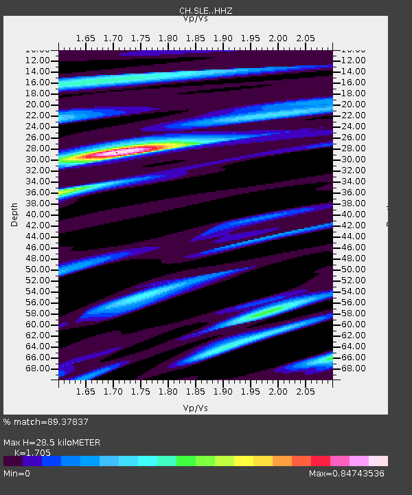
| Estimated Moho Depth: |
28.5 km |
| Estimated Crust Vp/Vs: |
1.71 |
| Assumed Crust Vp: |
6.416 km/s |
| Estimated Crust Vs: |
3.763 km/s |
| Estimated Crust Poisson's Ratio: |
0.24 |
|
| Radial Match: |
89.37837 % |
| Radial Bump: |
376 |
| Transverse Match: |
80.40412 % |
| Transverse Bump: |
400 |
| SOD ConfigId: |
7422571 |
| Insert Time: |
2019-04-21 23:54:44.443 +0000 |
| GWidth: |
2.5 |
| Max Bumps: |
400 |
| Tol: |
0.001 |
|

Signal To Noise
| Channel | StoN | STA | LTA |
| CH:SLE: :HHZ:20160302T13:02:17.871023Z | 3.6278546 | 1.588461E-6 | 4.3785133E-7 |
| CH:SLE: :HHN:20160302T13:02:17.871023Z | 1.4513786 | 6.8161546E-7 | 4.6963314E-7 |
| CH:SLE: :HHE:20160302T13:02:17.871023Z | 1.1602589 | 5.0019617E-7 | 4.311074E-7 |
| Arrivals |
| Ps | 3.2 SECOND |
| PpPs | 12 SECOND |
| PsPs/PpSs | 15 SECOND |


