You are here: Home > Network List > DK - Danish Seismological Network Stations List
> Station NOR Station Nord, Greenland > Earthquake Result Viewer
NOR Station Nord, Greenland - Earthquake Result Viewer
| Earthquake location: |
Southwest Of Sumatra, Indonesia |
| Earthquake latitude/longitude: |
-4.9/94.2 |
| Earthquake time(UTC): |
2016/03/02 (062) 12:49:46 GMT |
| Earthquake Depth: |
10 km |
| Earthquake Magnitude: |
7.9 MWW |
| Earthquake Catalog/Contributor: |
NEIC PDE/NEIC COMCAT |
|
| Network: |
DK Danish Seismological Network |
| Station: |
NOR Station Nord, Greenland |
| Lat/Lon: |
81.60 N/16.66 W |
| Elevation: |
36 m |
|
| Distance: |
97.8 deg |
| Az: |
352.034 deg |
| Baz: |
69.986 deg |
| Ray Param: |
0.040094804 |
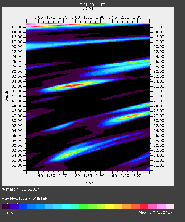
| Estimated Moho Depth: |
11.25 km |
| Estimated Crust Vp/Vs: |
1.60 |
| Assumed Crust Vp: |
6.459 km/s |
| Estimated Crust Vs: |
4.037 km/s |
| Estimated Crust Poisson's Ratio: |
0.18 |
|
| Radial Match: |
85.61334 % |
| Radial Bump: |
385 |
| Transverse Match: |
67.781685 % |
| Transverse Bump: |
400 |
| SOD ConfigId: |
7422571 |
| Insert Time: |
2019-04-21 23:54:49.770 +0000 |
| GWidth: |
2.5 |
| Max Bumps: |
400 |
| Tol: |
0.001 |
|

Signal To Noise
| Channel | StoN | STA | LTA |
| DK:NOR: :HHZ:20160302T13:02:49.979971Z | 3.4607341 | 9.450936E-7 | 2.730905E-7 |
| DK:NOR: :HHN:20160302T13:02:49.979971Z | 0.6748657 | 2.571811E-7 | 3.8108485E-7 |
| DK:NOR: :HHE:20160302T13:02:49.979971Z | 1.2457031 | 5.5163116E-7 | 4.4282712E-7 |
| Arrivals |
| Ps | 1.1 SECOND |
| PpPs | 4.4 SECOND |
| PsPs/PpSs | 5.5 SECOND |


