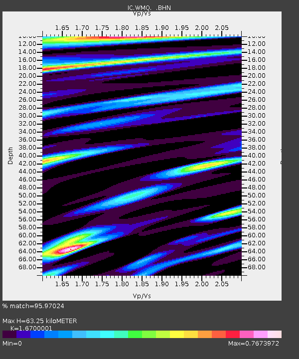
WMQ Urumqi, Xinjiang Province, China - Earthquake Result Viewer

Earthquake location: Rat Islands, Aleutian Islands
Earthquake latitude/longitude: 51.2/178.7
Earthquake time(UTC): 1996/03/22 (082) 03:24:20 GMT
Earthquake Depth: 20 km
Earthquake Magnitude: 5.7 MB, 6.6 MS, 6.8 UNKNOWN, 6.6 ML
Earthquake Catalog/Contributor: WHDF/NEIC
Network: IC New China Digital Seismograph Network
Station: WMQ Urumqi, Xinjiang Province, China
Lat/Lon: 43.82 N/87.69 E
Elevation: 903 m
Distance: 58.1 deg
Az: 301.514 deg
Baz: 47.789 deg
Ray Param: 0.063045405
Estimated Moho Depth: 63.25 km
Estimated Crust Vp/Vs: 1.67
Assumed Crust Vp: 6.242 km/s
Estimated Crust Vs: 3.738 km/s
Estimated Crust Poisson's Ratio: 0.22
Radial Match: 95.97024 %
Radial Bump: 400
Transverse Match: 87.0244 %
Transverse Bump: 400
SOD ConfigId: 6273
Insert Time: 2010-03-05 00:14:15.487 +0000
GWidth: 2.5
Max Bumps: 400
Tol: 0.001

Signal To Noise

ChannelStoNSTALTA
IC:WMQ: :BHN:19960322T03:33:40.901001Z8.77963354.0160734E-74.5743064E-8
IC:WMQ: :BHE:19960322T03:33:40.901001Z20.9495377.7677845E-73.7078546E-8
IC:WMQ: :BHZ:19960322T03:33:40.901001Z34.4737052.1621158E-66.2717824E-8
Arrivals
Ps7.1 SECOND
PpPs26 SECOND
PsPs/PpSs33 SECOND