You are here: Home > Network List > KN - Kyrgyz Seismic Telemetry Network Stations List
> Station EKS2 KN.EKS2 > Earthquake Result Viewer
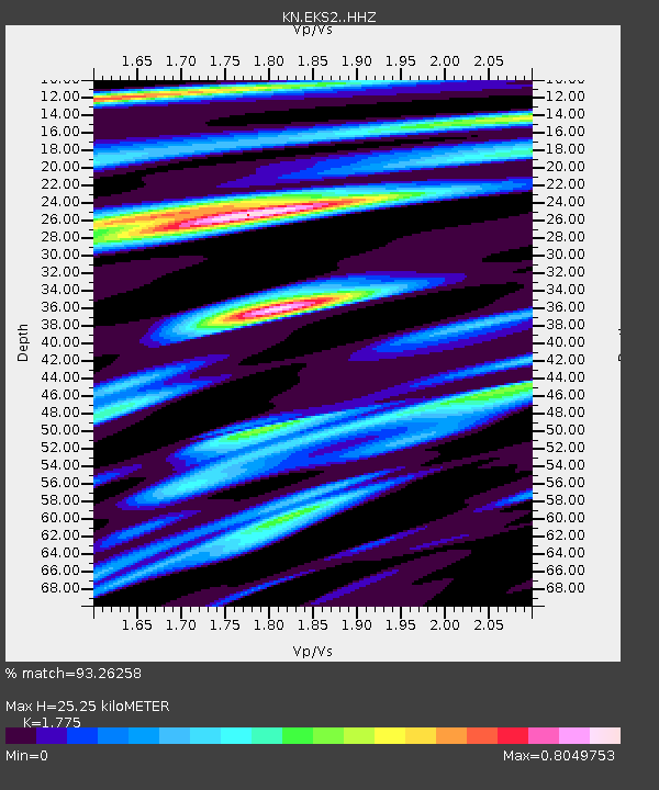
EKS2 KN.EKS2 - Earthquake Result Viewer
| Earthquake location: |
Southwest Of Sumatra, Indonesia |
| Earthquake latitude/longitude: |
-4.9/94.2 |
| Earthquake time(UTC): |
2016/03/02 (062) 12:49:46 GMT |
| Earthquake Depth: |
10 km |
| Earthquake Magnitude: |
7.9 MWW |
| Earthquake Catalog/Contributor: |
NEIC PDE/NEIC COMCAT |
|
| Network: |
KN Kyrgyz Seismic Telemetry Network |
| Station: |
EKS2 KN.EKS2 |
| Lat/Lon: |
42.66 N/73.78 E |
| Elevation: |
1360 m |
|
| Distance: |
50.9 deg |
| Az: |
340.583 deg |
| Baz: |
153.317 deg |
| Ray Param: |
0.06777731 |
| Estimated Moho Depth: |
25.25 km |
| Estimated Crust Vp/Vs: |
1.77 |
| Assumed Crust Vp: |
6.316 km/s |
| Estimated Crust Vs: |
3.558 km/s |
| Estimated Crust Poisson's Ratio: |
0.27 |
|
| Radial Match: |
93.26258 % |
| Radial Bump: |
398 |
| Transverse Match: |
79.259125 % |
| Transverse Bump: |
400 |
| SOD ConfigId: |
7422571 |
| Insert Time: |
2019-04-21 23:55:37.703 +0000 |
| GWidth: |
2.5 |
| Max Bumps: |
400 |
| Tol: |
0.001 |
|

Signal To Noise
| Channel | StoN | STA | LTA |
| KN:EKS2: :HHZ:20160302T12:58:16.559988Z | 27.160675 | 8.88318E-6 | 3.2706038E-7 |
| KN:EKS2: :HHN:20160302T12:58:16.559988Z | 15.046003 | 2.8248169E-6 | 1.8774531E-7 |
| KN:EKS2: :HHE:20160302T12:58:16.559988Z | 13.337901 | 1.9486206E-6 | 1.4609648E-7 |
| Arrivals |
| Ps | 3.3 SECOND |
| PpPs | 11 SECOND |
| PsPs/PpSs | 14 SECOND |


