You are here: Home > Network List > MN - MEDNET Project Stations List
> Station DIVS Divcibare,Serbia > Earthquake Result Viewer
DIVS Divcibare,Serbia - Earthquake Result Viewer

| Earthquake location: |
Southwest Of Sumatra, Indonesia |
| Earthquake latitude/longitude: |
-4.9/94.2 |
| Earthquake time(UTC): |
2016/03/02 (062) 12:49:46 GMT |
| Earthquake Depth: |
10 km |
| Earthquake Magnitude: |
7.9 MWW |
| Earthquake Catalog/Contributor: |
NEIC PDE/NEIC COMCAT |
|
| Network: |
MN MEDNET Project |
| Station: |
DIVS Divcibare,Serbia |
| Lat/Lon: |
44.10 N/19.99 E |
| Elevation: |
1000 m |
|
| Distance: |
82.2 deg |
| Az: |
315.58 deg |
| Baz: |
104.546 deg |
| Ray Param: |
0.04706509 |
| Estimated Moho Depth: |
20.25 km |
| Estimated Crust Vp/Vs: |
2.10 |
| Assumed Crust Vp: |
6.264 km/s |
| Estimated Crust Vs: |
2.986 km/s |
| Estimated Crust Poisson's Ratio: |
0.35 |
|
| Radial Match: |
95.956665 % |
| Radial Bump: |
400 |
| Transverse Match: |
93.194565 % |
| Transverse Bump: |
400 |
| SOD ConfigId: |
7422571 |
| Insert Time: |
2019-04-21 23:56:03.595 +0000 |
| GWidth: |
2.5 |
| Max Bumps: |
400 |
| Tol: |
0.001 |
|
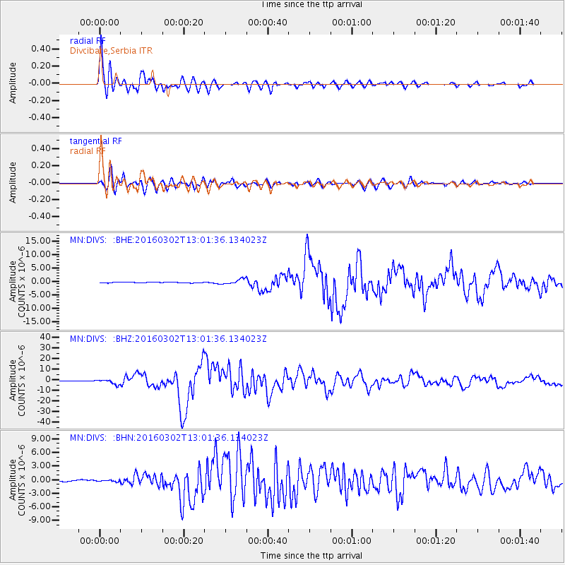
Signal To Noise
| Channel | StoN | STA | LTA |
| MN:DIVS: :BHZ:20160302T13:01:36.134023Z | 12.545202 | 2.2341644E-6 | 1.7808915E-7 |
| MN:DIVS: :BHN:20160302T13:01:36.134023Z | 1.1269162 | 1.4589575E-7 | 1.2946461E-7 |
| MN:DIVS: :BHE:20160302T13:01:36.134023Z | 6.008448 | 8.8573086E-7 | 1.4741424E-7 |
| Arrivals |
| Ps | 3.6 SECOND |
| PpPs | 9.8 SECOND |
| PsPs/PpSs | 13 SECOND |


