You are here: Home > Network List > S - Seismographs in Schools Projects Stations List
> Station AUKAL John Paul College, Kalgoorlie, WA > Earthquake Result Viewer
AUKAL John Paul College, Kalgoorlie, WA - Earthquake Result Viewer
| Earthquake location: |
Southwest Of Sumatra, Indonesia |
| Earthquake latitude/longitude: |
-4.9/94.2 |
| Earthquake time(UTC): |
2016/03/02 (062) 12:49:46 GMT |
| Earthquake Depth: |
10 km |
| Earthquake Magnitude: |
7.9 MWW |
| Earthquake Catalog/Contributor: |
NEIC PDE/NEIC COMCAT |
|
| Network: |
S Seismographs in Schools Projects |
| Station: |
AUKAL John Paul College, Kalgoorlie, WA |
| Lat/Lon: |
30.76 S/121.48 E |
| Elevation: |
373 m |
|
| Distance: |
36.3 deg |
| Az: |
138.291 deg |
| Baz: |
309.632 deg |
| Ray Param: |
0.07674712 |
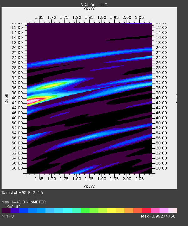
| Estimated Moho Depth: |
41.0 km |
| Estimated Crust Vp/Vs: |
1.62 |
| Assumed Crust Vp: |
6.459 km/s |
| Estimated Crust Vs: |
3.987 km/s |
| Estimated Crust Poisson's Ratio: |
0.19 |
|
| Radial Match: |
95.842415 % |
| Radial Bump: |
188 |
| Transverse Match: |
86.57347 % |
| Transverse Bump: |
400 |
| SOD ConfigId: |
7422571 |
| Insert Time: |
2019-04-21 23:56:32.483 +0000 |
| GWidth: |
2.5 |
| Max Bumps: |
400 |
| Tol: |
0.001 |
|

Signal To Noise
| Channel | StoN | STA | LTA |
| S:AUKAL: :HHZ:20160302T12:56:18.339987Z | 11.599025 | 7.1805393E-6 | 6.1906405E-7 |
| S:AUKAL: :HHN:20160302T12:56:18.339987Z | 7.3854856 | 3.7377793E-6 | 5.06098E-7 |
| S:AUKAL: :HHE:20160302T12:56:18.339987Z | 5.4023013 | 2.932491E-6 | 5.428226E-7 |
| Arrivals |
| Ps | 4.3 SECOND |
| PpPs | 15 SECOND |
| PsPs/PpSs | 20 SECOND |


