You are here: Home > Network List > CI - Caltech Regional Seismic Network Stations List
> Station BAR Barrett, Tecate, CA, USA > Earthquake Result Viewer
BAR Barrett, Tecate, CA, USA - Earthquake Result Viewer
| Earthquake location: |
Eastern Honshu, Japan |
| Earthquake latitude/longitude: |
39.8/141.5 |
| Earthquake time(UTC): |
2008/07/23 (205) 15:26:19 GMT |
| Earthquake Depth: |
108 km |
| Earthquake Magnitude: |
6.6 MB, 6.8 MW, 6.8 MW |
| Earthquake Catalog/Contributor: |
WHDF/NEIC |
|
| Network: |
CI Caltech Regional Seismic Network |
| Station: |
BAR Barrett, Tecate, CA, USA |
| Lat/Lon: |
32.68 N/116.67 W |
| Elevation: |
521 m |
|
| Distance: |
77.9 deg |
| Az: |
57.562 deg |
| Baz: |
309.561 deg |
| Ray Param: |
0.049735516 |
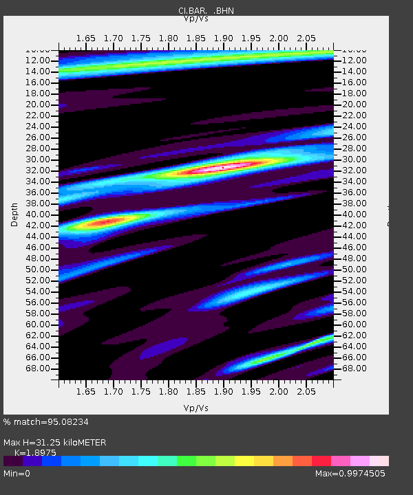
| Estimated Moho Depth: |
31.25 km |
| Estimated Crust Vp/Vs: |
1.90 |
| Assumed Crust Vp: |
6.264 km/s |
| Estimated Crust Vs: |
3.301 km/s |
| Estimated Crust Poisson's Ratio: |
0.31 |
|
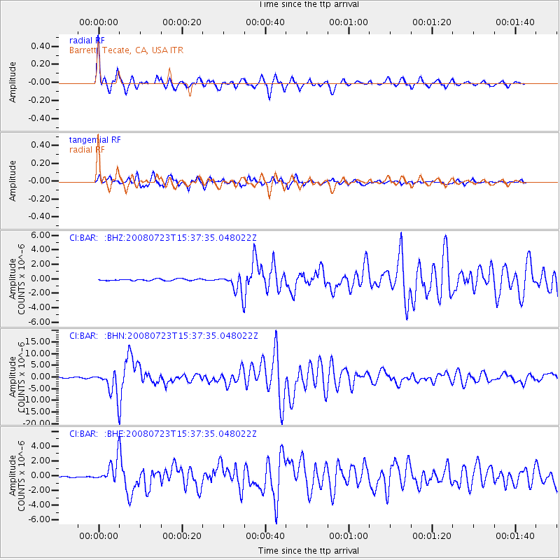
| Radial Match: |
95.08234 % |
| Radial Bump: |
399 |
| Transverse Match: |
92.57122 % |
| Transverse Bump: |
400 |
| SOD ConfigId: |
2504 |
| Insert Time: |
2010-02-26 00:08:46.047 +0000 |
| GWidth: |
2.5 |
| Max Bumps: |
400 |
| Tol: |
0.001 |
|
Signal To Noise
| Channel | StoN | STA | LTA |
| CI:BAR: :BHN:20080723T15:37:35.048022Z | 25.886616 | 5.5362534E-6 | 2.1386548E-7 |
| CI:BAR: :BHE:20080723T15:37:35.048022Z | 13.241071 | 1.5823287E-6 | 1.1950156E-7 |
| CI:BAR: :BHZ:20080723T15:37:35.048022Z | 13.423616 | 1.4422678E-6 | 1.07442574E-7 |
| Arrivals |
| Ps | 4.6 SECOND |
| PpPs | 14 SECOND |
| PsPs/PpSs | 19 SECOND |


