You are here: Home > Network List > S - Seismographs in Schools Projects Stations List
> Station AUUHS Ulladulla High School, Ulladulla, NSW > Earthquake Result Viewer
AUUHS Ulladulla High School, Ulladulla, NSW - Earthquake Result Viewer
| Earthquake location: |
Southwest Of Sumatra, Indonesia |
| Earthquake latitude/longitude: |
-4.9/94.2 |
| Earthquake time(UTC): |
2016/03/02 (062) 12:49:46 GMT |
| Earthquake Depth: |
10 km |
| Earthquake Magnitude: |
7.9 MWW |
| Earthquake Catalog/Contributor: |
NEIC PDE/NEIC COMCAT |
|
| Network: |
S Seismographs in Schools Projects |
| Station: |
AUUHS Ulladulla High School, Ulladulla, NSW |
| Lat/Lon: |
35.36 S/150.47 E |
| Elevation: |
44 m |
|
| Distance: |
59.9 deg |
| Az: |
128.238 deg |
| Baz: |
286.771 deg |
| Ray Param: |
0.06188867 |
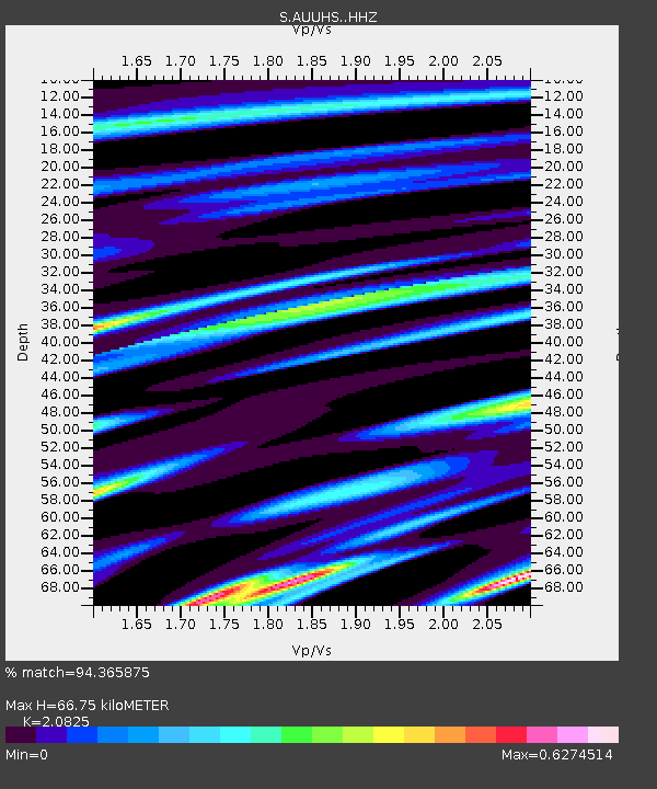
| Estimated Moho Depth: |
66.75 km |
| Estimated Crust Vp/Vs: |
2.08 |
| Assumed Crust Vp: |
6.472 km/s |
| Estimated Crust Vs: |
3.108 km/s |
| Estimated Crust Poisson's Ratio: |
0.35 |
|
| Radial Match: |
94.365875 % |
| Radial Bump: |
400 |
| Transverse Match: |
79.763756 % |
| Transverse Bump: |
400 |
| SOD ConfigId: |
7422571 |
| Insert Time: |
2019-04-21 23:56:42.049 +0000 |
| GWidth: |
2.5 |
| Max Bumps: |
400 |
| Tol: |
0.001 |
|

Signal To Noise
| Channel | StoN | STA | LTA |
| S:AUUHS: :HHZ:20160302T12:59:20.229971Z | 6.0110774 | 2.4561548E-6 | 4.0860476E-7 |
| S:AUUHS: :HHN:20160302T12:59:20.229971Z | 2.0199459 | 5.8213107E-7 | 2.8819144E-7 |
| S:AUUHS: :HHE:20160302T12:59:20.229971Z | 0.71760803 | 8.3195255E-7 | 1.1593412E-6 |
| Arrivals |
| Ps | 12 SECOND |
| PpPs | 31 SECOND |
| PsPs/PpSs | 42 SECOND |


