You are here: Home > Network List > IC - New China Digital Seismograph Network Stations List
> Station WMQ Urumqi, Xinjiang Province, China > Earthquake Result Viewer
WMQ Urumqi, Xinjiang Province, China - Earthquake Result Viewer

| Earthquake location: |
Off East Coast Of Kamchatka |
| Earthquake latitude/longitude: |
51.6/159.1 |
| Earthquake time(UTC): |
1996/06/21 (173) 13:57:10 GMT |
| Earthquake Depth: |
20 km |
| Earthquake Magnitude: |
6.0 MB, 6.6 MS, 7.0 UNKNOWN, 6.5 MS |
| Earthquake Catalog/Contributor: |
WHDF/NEIC |
|
| Network: |
IC New China Digital Seismograph Network |
| Station: |
WMQ Urumqi, Xinjiang Province, China |
| Lat/Lon: |
43.82 N/87.69 E |
| Elevation: |
903 m |
|
| Distance: |
46.9 deg |
| Az: |
290.057 deg |
| Baz: |
54.095 deg |
| Ray Param: |
0.07030741 |
| Estimated Moho Depth: |
16.25 km |
| Estimated Crust Vp/Vs: |
1.76 |
| Assumed Crust Vp: |
6.242 km/s |
| Estimated Crust Vs: |
3.542 km/s |
| Estimated Crust Poisson's Ratio: |
0.26 |
|
| Radial Match: |
96.25255 % |
| Radial Bump: |
390 |
| Transverse Match: |
85.34535 % |
| Transverse Bump: |
400 |
| SOD ConfigId: |
6273 |
| Insert Time: |
2010-03-05 00:14:40.532 +0000 |
| GWidth: |
2.5 |
| Max Bumps: |
400 |
| Tol: |
0.001 |
|
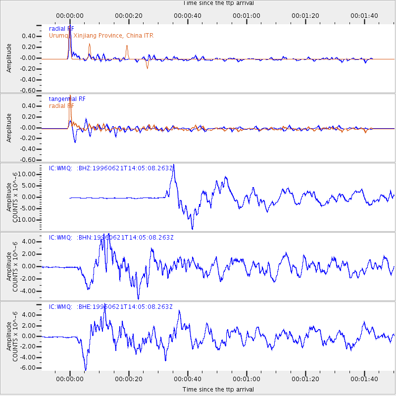
Signal To Noise
| Channel | StoN | STA | LTA |
| IC:WMQ: :BHN:19960621T14:05:08.263Z | 12.564625 | 5.429215E-7 | 4.321032E-8 |
| IC:WMQ: :BHE:19960621T14:05:08.263Z | 23.80099 | 1.3374104E-6 | 5.619138E-8 |
| IC:WMQ: :BHZ:19960621T14:05:08.263Z | 31.539011 | 3.2578262E-6 | 1.0329513E-7 |
| Arrivals |
| Ps | 2.1 SECOND |
| PpPs | 6.8 SECOND |
| PsPs/PpSs | 8.9 SECOND |


