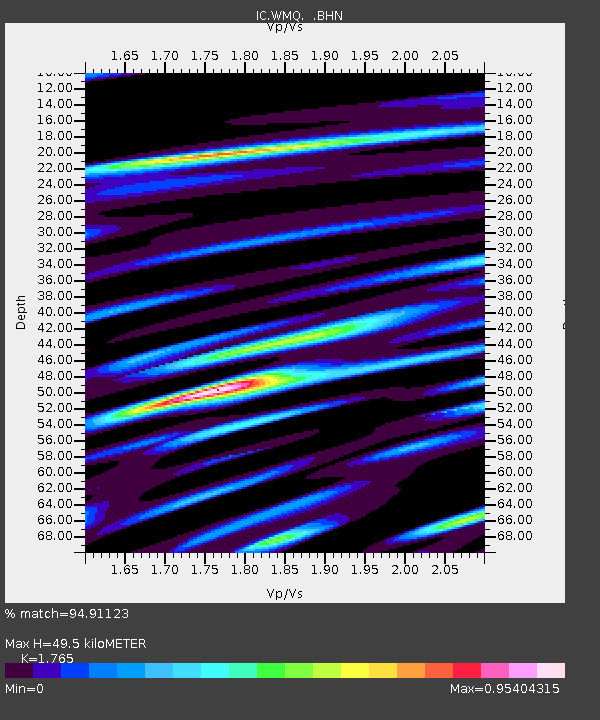
WMQ Urumqi, Xinjiang Province, China - Earthquake Result Viewer
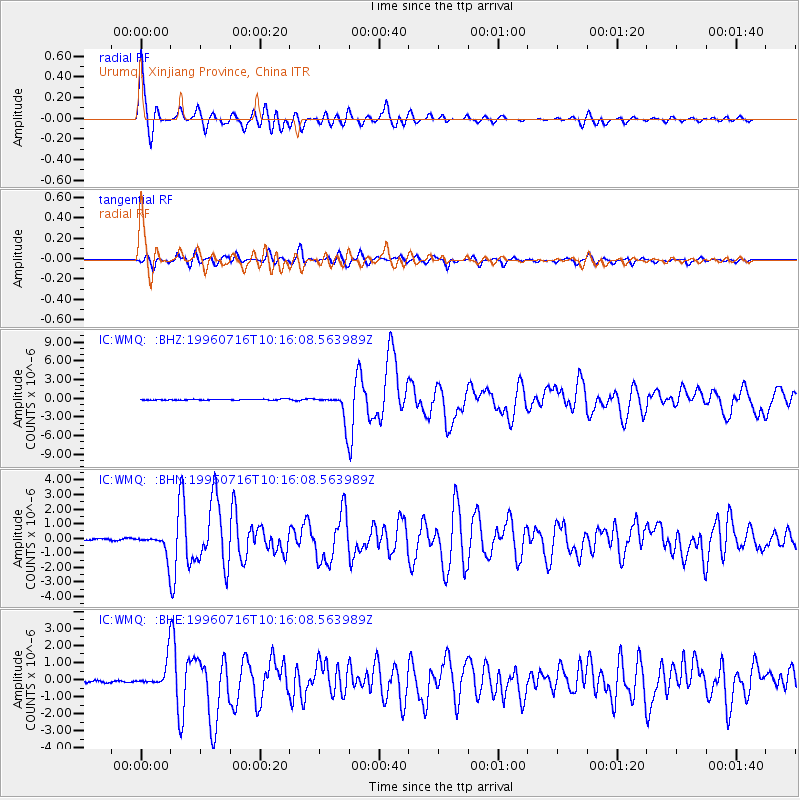
Earthquake location: Minahassa Peninsula, Sulawesi
Earthquake latitude/longitude: 1.0/120.3
Earthquake time(UTC): 1996/07/16 (198) 10:07:36 GMT
Earthquake Depth: 33 km
Earthquake Magnitude: 6.0 MB, 6.4 MS, 6.6 UNKNOWN, 6.6 MW
Earthquake Catalog/Contributor: WHDF/NEIC
Network: IC New China Digital Seismograph Network
Station: WMQ Urumqi, Xinjiang Province, China
Lat/Lon: 43.82 N/87.69 E
Elevation: 903 m
Distance: 51.5 deg
Az: 330.162 deg
Baz: 136.585 deg
Ray Param: 0.067292735
Estimated Moho Depth: 49.5 km
Estimated Crust Vp/Vs: 1.76
Assumed Crust Vp: 6.242 km/s
Estimated Crust Vs: 3.537 km/s
Estimated Crust Poisson's Ratio: 0.26
Radial Match: 94.91123 %
Radial Bump: 400
Transverse Match: 86.505936 %
Transverse Bump: 400
SOD ConfigId: 6273
Insert Time: 2010-03-05 00:14:52.251 +0000
GWidth: 2.5
Max Bumps: 400
Tol: 0.001

Signal To Noise

ChannelStoNSTALTA
IC:WMQ: :BHN:19960716T10:16:08.563989Z11.8486857.3975264E-76.243331E-8
IC:WMQ: :BHE:19960716T10:16:08.563989Z14.0956817.8706466E-75.583729E-8
IC:WMQ: :BHZ:19960716T10:16:08.563989Z28.7620682.258161E-67.8511775E-8
Arrivals
Ps6.4 SECOND
PpPs21 SECOND
PsPs/PpSs27 SECOND