You are here: Home > Network List > YT07 - POLENET Stations List
> Station MA03 Polenet mini-array MA03 > Earthquake Result Viewer
MA03 Polenet mini-array MA03 - Earthquake Result Viewer
| Earthquake location: |
Southwest Of Sumatra, Indonesia |
| Earthquake latitude/longitude: |
-4.9/94.2 |
| Earthquake time(UTC): |
2016/03/02 (062) 12:49:46 GMT |
| Earthquake Depth: |
10 km |
| Earthquake Magnitude: |
7.9 MWW |
| Earthquake Catalog/Contributor: |
NEIC PDE/NEIC COMCAT |
|
| Network: |
YT POLENET |
| Station: |
MA03 Polenet mini-array MA03 |
| Lat/Lon: |
77.94 S/97.56 W |
| Elevation: |
1622 m |
|
| Distance: |
97.0 deg |
| Az: |
177.518 deg |
| Baz: |
191.841 deg |
| Ray Param: |
0.040342893 |
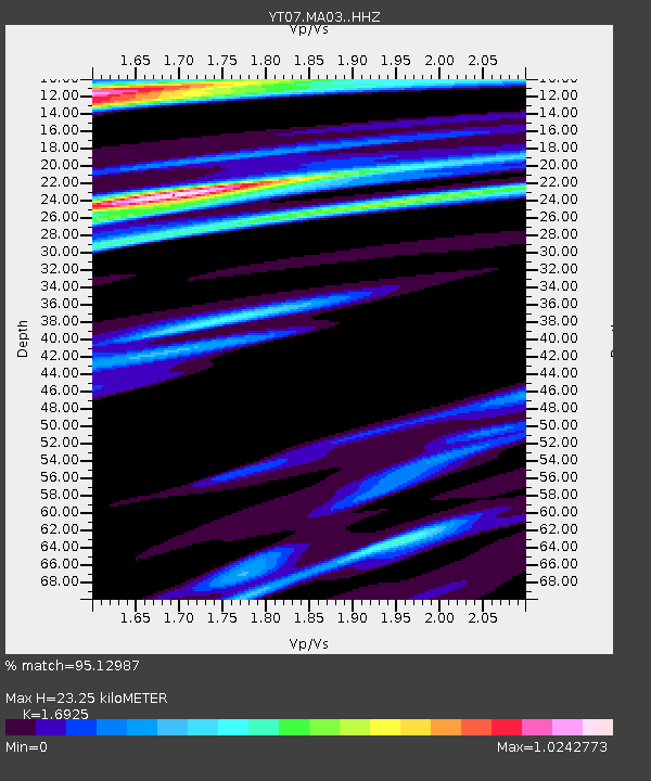
| Estimated Moho Depth: |
23.25 km |
| Estimated Crust Vp/Vs: |
1.69 |
| Assumed Crust Vp: |
5.77 km/s |
| Estimated Crust Vs: |
3.409 km/s |
| Estimated Crust Poisson's Ratio: |
0.23 |
|
| Radial Match: |
95.12987 % |
| Radial Bump: |
292 |
| Transverse Match: |
88.951294 % |
| Transverse Bump: |
400 |
| SOD ConfigId: |
7422571 |
| Insert Time: |
2019-04-21 23:57:53.359 +0000 |
| GWidth: |
2.5 |
| Max Bumps: |
400 |
| Tol: |
0.001 |
|

Signal To Noise
| Channel | StoN | STA | LTA |
| YT:MA03: :HHZ:20160302T13:02:45.82897Z | 3.9480524 | 8.9655174E-7 | 2.270871E-7 |
| YT:MA03: :HHN:20160302T13:02:45.82897Z | 1.7525297 | 7.2779244E-7 | 4.1528108E-7 |
| YT:MA03: :HHE:20160302T13:02:45.82897Z | 0.94076496 | 3.011887E-7 | 3.2015296E-7 |
| Arrivals |
| Ps | 2.8 SECOND |
| PpPs | 11 SECOND |
| PsPs/PpSs | 14 SECOND |


