You are here: Home > Network List > YT07 - POLENET Stations List
> Station P061 P061 > Earthquake Result Viewer
P061 P061 - Earthquake Result Viewer
| Earthquake location: |
Southwest Of Sumatra, Indonesia |
| Earthquake latitude/longitude: |
-4.9/94.2 |
| Earthquake time(UTC): |
2016/03/02 (062) 12:49:46 GMT |
| Earthquake Depth: |
10 km |
| Earthquake Magnitude: |
7.9 MWW |
| Earthquake Catalog/Contributor: |
NEIC PDE/NEIC COMCAT |
|
| Network: |
YT POLENET |
| Station: |
P061 P061 |
| Lat/Lon: |
84.50 S/77.22 E |
| Elevation: |
1758 m |
|
| Distance: |
79.8 deg |
| Az: |
181.643 deg |
| Baz: |
17.227 deg |
| Ray Param: |
0.048688147 |
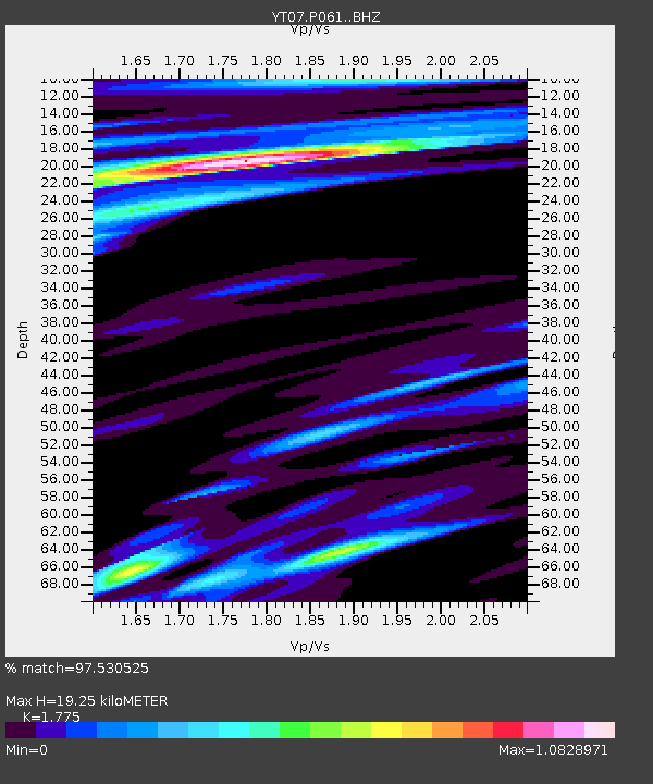
| Estimated Moho Depth: |
19.25 km |
| Estimated Crust Vp/Vs: |
1.77 |
| Assumed Crust Vp: |
6.261 km/s |
| Estimated Crust Vs: |
3.527 km/s |
| Estimated Crust Poisson's Ratio: |
0.27 |
|
| Radial Match: |
97.530525 % |
| Radial Bump: |
400 |
| Transverse Match: |
93.35403 % |
| Transverse Bump: |
400 |
| SOD ConfigId: |
7422571 |
| Insert Time: |
2019-04-21 23:58:00.457 +0000 |
| GWidth: |
2.5 |
| Max Bumps: |
400 |
| Tol: |
0.001 |
|

Signal To Noise
| Channel | StoN | STA | LTA |
| YT:P061: :BHZ:20160302T13:01:22.924978Z | 18.324913 | 6.469148E-6 | 3.5302477E-7 |
| YT:P061: :BHN:20160302T13:01:22.924978Z | 8.345818 | 1.6489197E-6 | 1.9757437E-7 |
| YT:P061: :BHE:20160302T13:01:22.924978Z | 1.4077452 | 6.435334E-7 | 4.5713767E-7 |
| Arrivals |
| Ps | 2.4 SECOND |
| PpPs | 8.3 SECOND |
| PsPs/PpSs | 11 SECOND |


