You are here: Home > Network List > YT07 - POLENET Stations List
> Station SILY SILY > Earthquake Result Viewer
SILY SILY - Earthquake Result Viewer
| Earthquake location: |
Southwest Of Sumatra, Indonesia |
| Earthquake latitude/longitude: |
-4.9/94.2 |
| Earthquake time(UTC): |
2016/03/02 (062) 12:49:46 GMT |
| Earthquake Depth: |
10 km |
| Earthquake Magnitude: |
7.9 MWW |
| Earthquake Catalog/Contributor: |
NEIC PDE/NEIC COMCAT |
|
| Network: |
YT POLENET |
| Station: |
SILY SILY |
| Lat/Lon: |
77.13 S/125.97 W |
| Elevation: |
2093 m |
|
| Distance: |
95.0 deg |
| Az: |
171.65 deg |
| Baz: |
220.214 deg |
| Ray Param: |
0.04088907 |
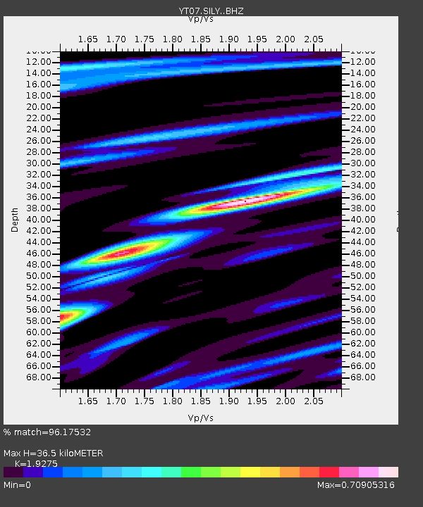
| Estimated Moho Depth: |
36.5 km |
| Estimated Crust Vp/Vs: |
1.93 |
| Assumed Crust Vp: |
6.138 km/s |
| Estimated Crust Vs: |
3.184 km/s |
| Estimated Crust Poisson's Ratio: |
0.32 |
|
| Radial Match: |
96.17532 % |
| Radial Bump: |
331 |
| Transverse Match: |
94.59277 % |
| Transverse Bump: |
400 |
| SOD ConfigId: |
7422571 |
| Insert Time: |
2019-04-21 23:58:03.660 +0000 |
| GWidth: |
2.5 |
| Max Bumps: |
400 |
| Tol: |
0.001 |
|

Signal To Noise
| Channel | StoN | STA | LTA |
| YT:SILY: :BHZ:20160302T13:02:36.898977Z | 3.6465635 | 9.4945324E-7 | 2.6036932E-7 |
| YT:SILY: :BHN:20160302T13:02:36.898977Z | 1.4839692 | 2.1666189E-7 | 1.4600161E-7 |
| YT:SILY: :BHE:20160302T13:02:36.898977Z | 0.97756445 | 1.3877246E-7 | 1.4195736E-7 |
| Arrivals |
| Ps | 5.6 SECOND |
| PpPs | 17 SECOND |
| PsPs/PpSs | 23 SECOND |


