You are here: Home > Network List > IC - New China Digital Seismograph Network Stations List
> Station WMQ Urumqi, Xinjiang Province, China > Earthquake Result Viewer
WMQ Urumqi, Xinjiang Province, China - Earthquake Result Viewer
| Earthquake location: |
Kyushu, Japan |
| Earthquake latitude/longitude: |
31.8/131.3 |
| Earthquake time(UTC): |
1996/12/02 (337) 22:17:59 GMT |
| Earthquake Depth: |
49 km |
| Earthquake Magnitude: |
6.0 MB, 6.6 MS, 6.8 UNKNOWN, 6.3 ME |
| Earthquake Catalog/Contributor: |
WHDF/NEIC |
|
| Network: |
IC New China Digital Seismograph Network |
| Station: |
WMQ Urumqi, Xinjiang Province, China |
| Lat/Lon: |
43.82 N/87.69 E |
| Elevation: |
903 m |
|
| Distance: |
36.1 deg |
| Az: |
302.07 deg |
| Baz: |
94.469 deg |
| Ray Param: |
0.0767405 |
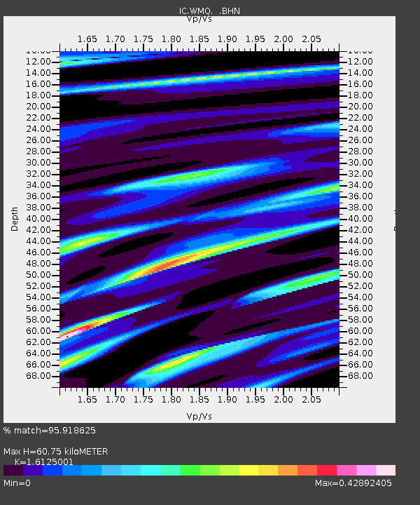
| Estimated Moho Depth: |
60.75 km |
| Estimated Crust Vp/Vs: |
1.61 |
| Assumed Crust Vp: |
6.242 km/s |
| Estimated Crust Vs: |
3.871 km/s |
| Estimated Crust Poisson's Ratio: |
0.19 |
|
| Radial Match: |
95.918625 % |
| Radial Bump: |
228 |
| Transverse Match: |
75.60557 % |
| Transverse Bump: |
400 |
| SOD ConfigId: |
6273 |
| Insert Time: |
2010-03-05 00:15:36.559 +0000 |
| GWidth: |
2.5 |
| Max Bumps: |
400 |
| Tol: |
0.001 |
|
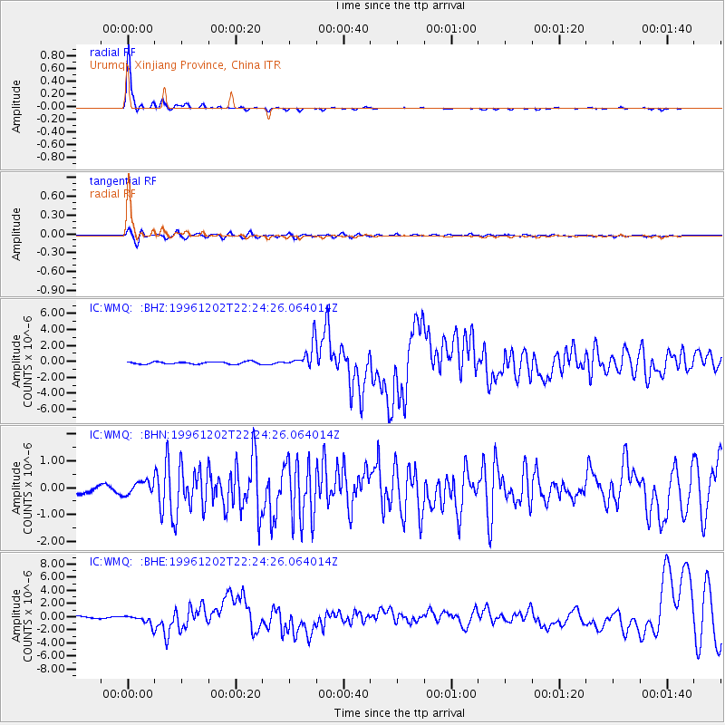
Signal To Noise
| Channel | StoN | STA | LTA |
| IC:WMQ: :BHN:19961202T22:24:26.064014Z | 1.7483182 | 2.5916813E-7 | 1.4823854E-7 |
| IC:WMQ: :BHE:19961202T22:24:26.064014Z | 7.5965137 | 8.203845E-7 | 1.0799487E-7 |
| IC:WMQ: :BHZ:19961202T22:24:26.064014Z | 11.263724 | 1.6412761E-6 | 1.4571344E-7 |
| Arrivals |
| Ps | 6.4 SECOND |
| PpPs | 24 SECOND |
| PsPs/PpSs | 30 SECOND |


