You are here: Home > Network List > XL12 - Hangay Dome, Mongolia Stations List
> Station HV26 HV26 > Earthquake Result Viewer
HV26 HV26 - Earthquake Result Viewer
| Earthquake location: |
Southwest Of Sumatra, Indonesia |
| Earthquake latitude/longitude: |
-4.8/94.4 |
| Earthquake time(UTC): |
2016/03/03 (063) 00:10:50 GMT |
| Earthquake Depth: |
10 km |
| Earthquake Magnitude: |
5.5 MB |
| Earthquake Catalog/Contributor: |
NEIC PDE/NEIC COMCAT |
|
| Network: |
XL Hangay Dome, Mongolia |
| Station: |
HV26 HV26 |
| Lat/Lon: |
50.62 N/101.86 E |
| Elevation: |
1158 m |
|
| Distance: |
55.6 deg |
| Az: |
5.743 deg |
| Baz: |
189.007 deg |
| Ray Param: |
0.064685114 |
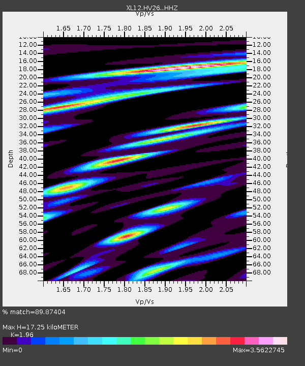
| Estimated Moho Depth: |
17.25 km |
| Estimated Crust Vp/Vs: |
1.96 |
| Assumed Crust Vp: |
6.419 km/s |
| Estimated Crust Vs: |
3.275 km/s |
| Estimated Crust Poisson's Ratio: |
0.32 |
|
| Radial Match: |
89.87404 % |
| Radial Bump: |
400 |
| Transverse Match: |
80.53958 % |
| Transverse Bump: |
400 |
| SOD ConfigId: |
7422571 |
| Insert Time: |
2019-04-22 00:01:08.384 +0000 |
| GWidth: |
2.5 |
| Max Bumps: |
400 |
| Tol: |
0.001 |
|

Signal To Noise
| Channel | StoN | STA | LTA |
| XL:HV26: :HHZ:20160303T00:19:54.859009Z | 2.0105853 | 2.0743701E-7 | 1.03172454E-7 |
| XL:HV26: :HHN:20160303T00:19:54.859009Z | 1.1355007 | 9.500564E-8 | 8.366851E-8 |
| XL:HV26: :HHE:20160303T00:19:54.859009Z | 1.5127518 | 1.2330399E-7 | 8.150973E-8 |
| Arrivals |
| Ps | 2.7 SECOND |
| PpPs | 7.6 SECOND |
| PsPs/PpSs | 10 SECOND |


