You are here: Home > Network List > IC - New China Digital Seismograph Network Stations List
> Station WMQ Urumqi, Xinjiang Province, China > Earthquake Result Viewer
WMQ Urumqi, Xinjiang Province, China - Earthquake Result Viewer
| Earthquake location: |
Eastern New Guinea Reg., P.N.G. |
| Earthquake latitude/longitude: |
-6.5/147.4 |
| Earthquake time(UTC): |
1997/04/05 (095) 12:23:30 GMT |
| Earthquake Depth: |
69 km |
| Earthquake Magnitude: |
6.1 MB, 6.5 UNKNOWN, 6.4 MW |
| Earthquake Catalog/Contributor: |
WHDF/NEIC |
|
| Network: |
IC New China Digital Seismograph Network |
| Station: |
WMQ Urumqi, Xinjiang Province, China |
| Lat/Lon: |
43.82 N/87.69 E |
| Elevation: |
903 m |
|
| Distance: |
73.4 deg |
| Az: |
319.297 deg |
| Baz: |
116.456 deg |
| Ray Param: |
0.052865077 |
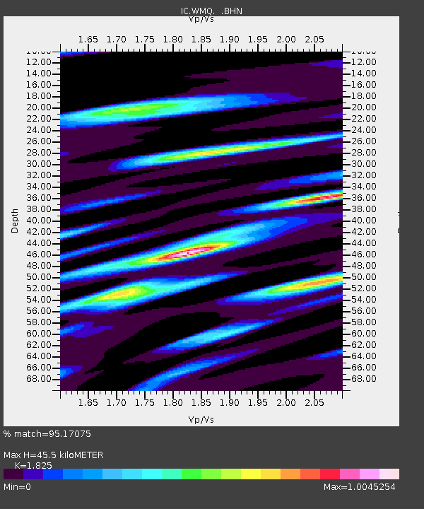
| Estimated Moho Depth: |
45.5 km |
| Estimated Crust Vp/Vs: |
1.83 |
| Assumed Crust Vp: |
6.242 km/s |
| Estimated Crust Vs: |
3.42 km/s |
| Estimated Crust Poisson's Ratio: |
0.29 |
|
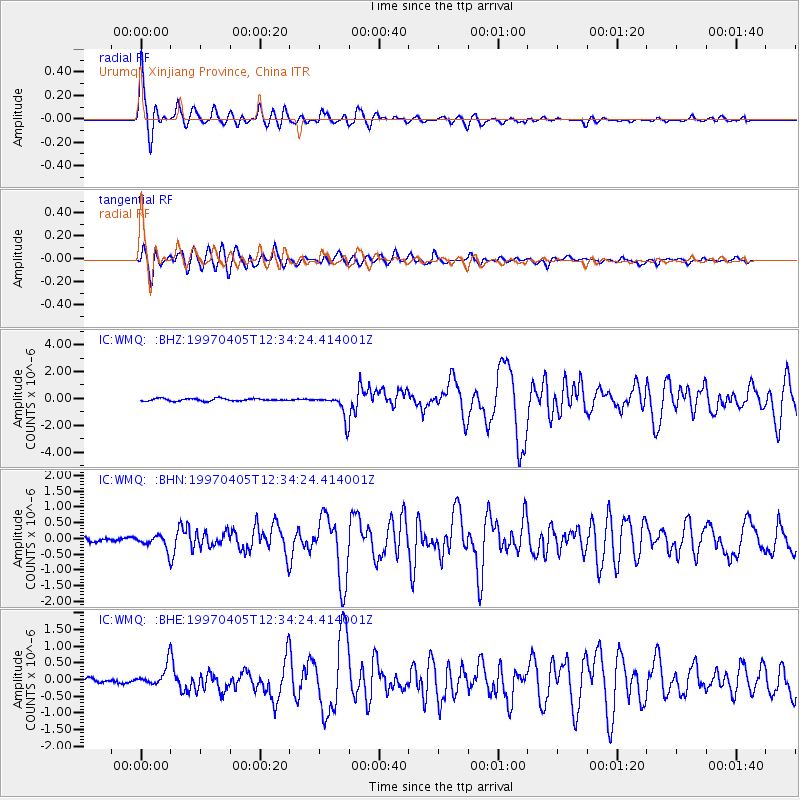
| Radial Match: |
95.17075 % |
| Radial Bump: |
400 |
| Transverse Match: |
90.63084 % |
| Transverse Bump: |
400 |
| SOD ConfigId: |
6273 |
| Insert Time: |
2010-03-05 00:15:59.125 +0000 |
| GWidth: |
2.5 |
| Max Bumps: |
400 |
| Tol: |
0.001 |
|
Signal To Noise
| Channel | StoN | STA | LTA |
| IC:WMQ: :BHN:19970405T12:34:24.414001Z | 2.7912748 | 2.3276573E-7 | 8.3390475E-8 |
| IC:WMQ: :BHE:19970405T12:34:24.414001Z | 3.1971788 | 3.2482353E-7 | 1.0159692E-7 |
| IC:WMQ: :BHZ:19970405T12:34:24.414001Z | 9.459179 | 8.876203E-7 | 9.3836924E-8 |
| Arrivals |
| Ps | 6.2 SECOND |
| PpPs | 20 SECOND |
| PsPs/PpSs | 26 SECOND |


