You are here: Home > Network List > PS - Pacific21 Stations List
> Station PSI Parapat, Indonesia > Earthquake Result Viewer
PSI Parapat, Indonesia - Earthquake Result Viewer
| Earthquake location: |
Bismarck Sea |
| Earthquake latitude/longitude: |
-3.3/148.8 |
| Earthquake time(UTC): |
2016/03/03 (063) 21:47:50 GMT |
| Earthquake Depth: |
10 km |
| Earthquake Magnitude: |
5.9 mwc |
| Earthquake Catalog/Contributor: |
NEIC PDE/ |
|
| Network: |
PS Pacific21 |
| Station: |
PSI Parapat, Indonesia |
| Lat/Lon: |
2.69 N/98.92 E |
| Elevation: |
987 m |
|
| Distance: |
50.2 deg |
| Az: |
276.253 deg |
| Baz: |
96.548 deg |
| Ray Param: |
0.06819334 |
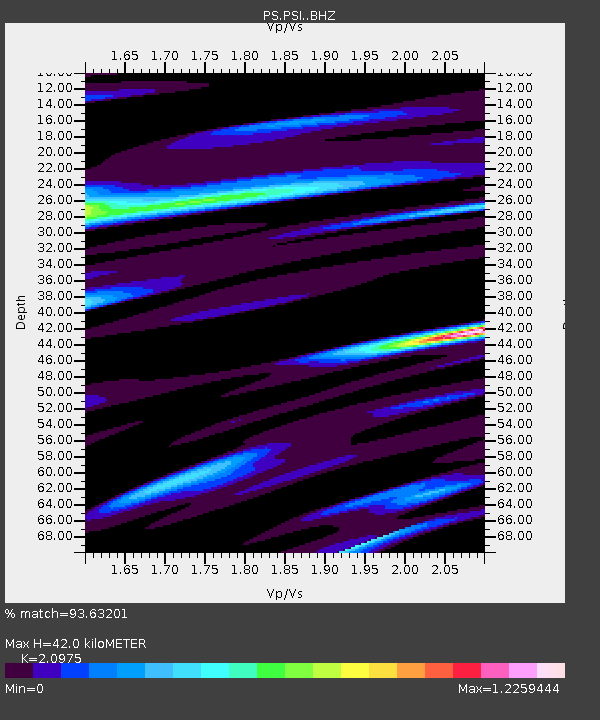
| Estimated Moho Depth: |
42.0 km |
| Estimated Crust Vp/Vs: |
2.10 |
| Assumed Crust Vp: |
6.468 km/s |
| Estimated Crust Vs: |
3.084 km/s |
| Estimated Crust Poisson's Ratio: |
0.35 |
|
| Radial Match: |
93.63201 % |
| Radial Bump: |
319 |
| Transverse Match: |
55.234814 % |
| Transverse Bump: |
400 |
| SOD ConfigId: |
7422571 |
| Insert Time: |
2019-04-22 00:08:07.880 +0000 |
| GWidth: |
2.5 |
| Max Bumps: |
400 |
| Tol: |
0.001 |
|
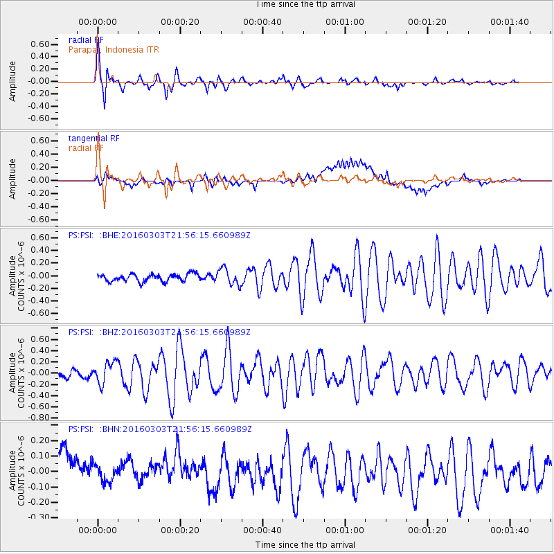
Signal To Noise
| Channel | StoN | STA | LTA |
| PS:PSI: :BHZ:20160303T21:56:15.660989Z | 2.349691 | 2.0227078E-7 | 8.608399E-8 |
| PS:PSI: :BHN:20160303T21:56:15.660989Z | 0.5088492 | 1.10999295E-7 | 2.1813788E-7 |
| PS:PSI: :BHE:20160303T21:56:15.660989Z | 2.27498 | 1.3379692E-7 | 5.8812347E-8 |
| Arrivals |
| Ps | 7.5 SECOND |
| PpPs | 19 SECOND |
| PsPs/PpSs | 27 SECOND |


