You are here: Home > Network List > TA - USArray Transportable Network (new EarthScope stations) Stations List
> Station J20K Nowitna River, AK, USA > Earthquake Result Viewer
J20K Nowitna River, AK, USA - Earthquake Result Viewer
*The percent match for this event was below the threshold and hence no stack was calculated.
| Earthquake location: |
Bismarck Sea |
| Earthquake latitude/longitude: |
-3.3/148.8 |
| Earthquake time(UTC): |
2016/03/03 (063) 21:47:50 GMT |
| Earthquake Depth: |
10 km |
| Earthquake Magnitude: |
5.9 mwc |
| Earthquake Catalog/Contributor: |
NEIC PDE/ |
|
| Network: |
TA USArray Transportable Network (new EarthScope stations) |
| Station: |
J20K Nowitna River, AK, USA |
| Lat/Lon: |
64.18 N/154.15 W |
| Elevation: |
314 m |
|
| Distance: |
79.3 deg |
| Az: |
21.96 deg |
| Baz: |
238.478 deg |
| Ray Param: |
$rayparam |
*The percent match for this event was below the threshold and hence was not used in the summary stack. |
|
| Radial Match: |
44.18868 % |
| Radial Bump: |
379 |
| Transverse Match: |
76.458664 % |
| Transverse Bump: |
400 |
| SOD ConfigId: |
7422571 |
| Insert Time: |
2019-04-22 00:08:29.609 +0000 |
| GWidth: |
2.5 |
| Max Bumps: |
400 |
| Tol: |
0.001 |
|
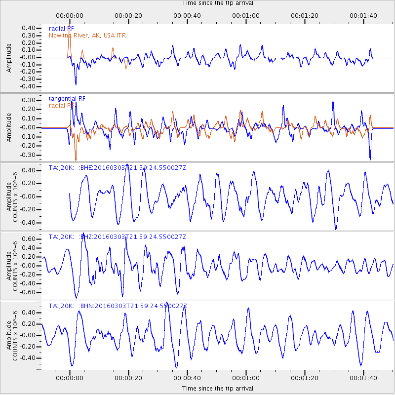
Signal To Noise
| Channel | StoN | STA | LTA |
| TA:J20K: :BHZ:20160303T21:59:24.550027Z | 2.4321098 | 4.6510468E-7 | 1.9123506E-7 |
| TA:J20K: :BHN:20160303T21:59:24.550027Z | 1.5161661 | 3.352669E-7 | 2.2112808E-7 |
| TA:J20K: :BHE:20160303T21:59:24.550027Z | 0.48713708 | 1.1824373E-7 | 2.4273194E-7 |
| Arrivals |
| Ps | |
| PpPs | |
| PsPs/PpSs | |


