You are here: Home > Network List > IC - New China Digital Seismograph Network Stations List
> Station WMQ Urumqi, Xinjiang Province, China > Earthquake Result Viewer
WMQ Urumqi, Xinjiang Province, China - Earthquake Result Viewer

| Earthquake location: |
Mid-Indian Ridge |
| Earthquake latitude/longitude: |
-11.4/66.2 |
| Earthquake time(UTC): |
1998/03/22 (081) 01:08:57 GMT |
| Earthquake Depth: |
10 km |
| Earthquake Magnitude: |
5.4 MB, 6.1 MS, 6.1 UNKNOWN, 6.1 MW |
| Earthquake Catalog/Contributor: |
WHDF/NEIC |
|
| Network: |
IC New China Digital Seismograph Network |
| Station: |
WMQ Urumqi, Xinjiang Province, China |
| Lat/Lon: |
43.82 N/87.69 E |
| Elevation: |
903 m |
|
| Distance: |
58.4 deg |
| Az: |
18.115 deg |
| Baz: |
204.907 deg |
| Ray Param: |
0.06289824 |
| Estimated Moho Depth: |
25.25 km |
| Estimated Crust Vp/Vs: |
1.80 |
| Assumed Crust Vp: |
6.242 km/s |
| Estimated Crust Vs: |
3.463 km/s |
| Estimated Crust Poisson's Ratio: |
0.28 |
|
| Radial Match: |
96.9917 % |
| Radial Bump: |
345 |
| Transverse Match: |
89.977394 % |
| Transverse Bump: |
400 |
| SOD ConfigId: |
6273 |
| Insert Time: |
2010-03-05 00:17:10.061 +0000 |
| GWidth: |
2.5 |
| Max Bumps: |
400 |
| Tol: |
0.001 |
|
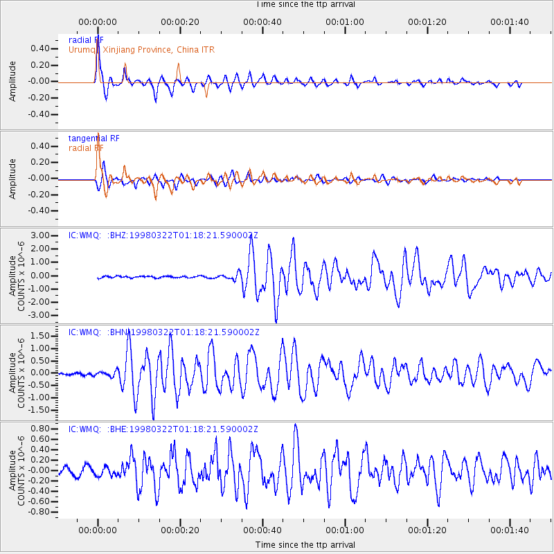
Signal To Noise
| Channel | StoN | STA | LTA |
| IC:WMQ: :BHN:19980322T01:18:21.590002Z | 1.5939968 | 1.0461252E-7 | 6.562907E-8 |
| IC:WMQ: :BHE:19980322T01:18:21.590002Z | 1.5025403 | 7.942681E-8 | 5.2861683E-8 |
| IC:WMQ: :BHZ:19980322T01:18:21.590002Z | 3.9781122 | 2.4007716E-7 | 6.034952E-8 |
| Arrivals |
| Ps | 3.4 SECOND |
| PpPs | 11 SECOND |
| PsPs/PpSs | 14 SECOND |


