You are here: Home > Network List > CI - Caltech Regional Seismic Network Stations List
> Station BAR Barrett, Tecate, CA, USA > Earthquake Result Viewer
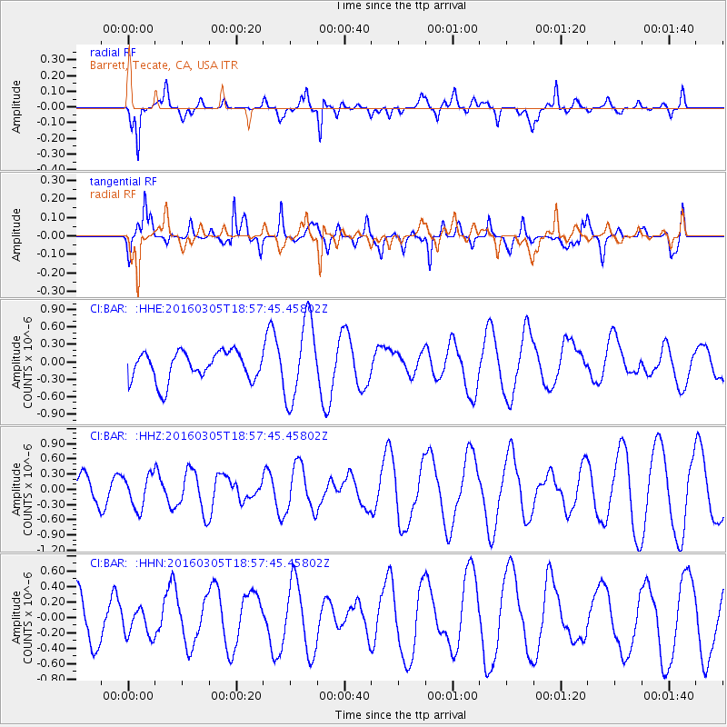
BAR Barrett, Tecate, CA, USA - Earthquake Result Viewer
*The percent match for this event was below the threshold and hence no stack was calculated.
| Earthquake location: |
South Of Kermadec Islands |
| Earthquake latitude/longitude: |
-32.9/-178.2 |
| Earthquake time(UTC): |
2016/03/05 (065) 18:45:30 GMT |
| Earthquake Depth: |
10 km |
| Earthquake Magnitude: |
5.5 MB |
| Earthquake Catalog/Contributor: |
NEIC PDE/NEIC COMCAT |
|
| Network: |
CI Caltech Regional Seismic Network |
| Station: |
BAR Barrett, Tecate, CA, USA |
| Lat/Lon: |
32.68 N/116.67 W |
| Elevation: |
521 m |
|
| Distance: |
87.3 deg |
| Az: |
47.917 deg |
| Baz: |
227.749 deg |
| Ray Param: |
$rayparam |
*The percent match for this event was below the threshold and hence was not used in the summary stack. |
|
| Radial Match: |
69.75066 % |
| Radial Bump: |
394 |
| Transverse Match: |
53.147713 % |
| Transverse Bump: |
386 |
| SOD ConfigId: |
7422571 |
| Insert Time: |
2019-04-22 00:16:40.117 +0000 |
| GWidth: |
2.5 |
| Max Bumps: |
400 |
| Tol: |
0.001 |
|
Signal To Noise
| Channel | StoN | STA | LTA |
| CI:BAR: :HHZ:20160305T18:57:45.45802Z | 0.73535377 | 3.2771024E-7 | 4.4564976E-7 |
| CI:BAR: :HHN:20160305T18:57:45.45802Z | 0.54013824 | 1.8641146E-7 | 3.4511805E-7 |
| CI:BAR: :HHE:20160305T18:57:45.45802Z | 2.8214672 | 6.967956E-7 | 2.4696214E-7 |
| Arrivals |
| Ps | |
| PpPs | |
| PsPs/PpSs | |


