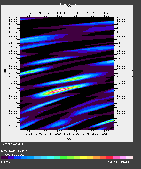
WMQ Urumqi, Xinjiang Province, China - Earthquake Result Viewer

Earthquake location: Minahassa Peninsula, Sulawesi
Earthquake latitude/longitude: 0.2/119.6
Earthquake time(UTC): 1998/05/21 (141) 05:34:25 GMT
Earthquake Depth: 33 km
Earthquake Magnitude: 6.2 MB, 6.3 MS, 6.6 UNKNOWN, 6.6 MW
Earthquake Catalog/Contributor: WHDF/NEIC
Network: IC New China Digital Seismograph Network
Station: WMQ Urumqi, Xinjiang Province, China
Lat/Lon: 43.82 N/87.69 E
Elevation: 903 m
Distance: 51.9 deg
Az: 330.927 deg
Baz: 137.831 deg
Ray Param: 0.06704681
Estimated Moho Depth: 49.0 km
Estimated Crust Vp/Vs: 1.81
Assumed Crust Vp: 6.242 km/s
Estimated Crust Vs: 3.458 km/s
Estimated Crust Poisson's Ratio: 0.28
Radial Match: 94.85837 %
Radial Bump: 400
Transverse Match: 89.75204 %
Transverse Bump: 400
SOD ConfigId: 4480
Insert Time: 2010-03-05 00:17:49.332 +0000
GWidth: 2.5
Max Bumps: 400
Tol: 0.001

Signal To Noise

ChannelStoNSTALTA
IC:WMQ: :BHN:19980521T05:43:00.163025Z41.0215952.3563723E-65.7442236E-8
IC:WMQ: :BHE:19980521T05:43:00.163025Z14.1360377.601279E-75.3772347E-8
IC:WMQ: :BHZ:19980521T05:43:00.163025Z17.9430277.276397E-74.0552784E-8
Arrivals
Ps6.7 SECOND
PpPs21 SECOND
PsPs/PpSs28 SECOND