You are here: Home > Network List > IC - New China Digital Seismograph Network Stations List
> Station WMQ Urumqi, Xinjiang Province, China > Earthquake Result Viewer
WMQ Urumqi, Xinjiang Province, China - Earthquake Result Viewer
| Earthquake location: |
Eastern Honshu, Japan |
| Earthquake latitude/longitude: |
39.7/140.8 |
| Earthquake time(UTC): |
1998/09/03 (246) 07:58:21 GMT |
| Earthquake Depth: |
38 km |
| Earthquake Magnitude: |
5.7 MB, 5.7 MS, 5.9 UNKNOWN, 5.9 MW |
| Earthquake Catalog/Contributor: |
WHDF/NEIC |
|
| Network: |
IC New China Digital Seismograph Network |
| Station: |
WMQ Urumqi, Xinjiang Province, China |
| Lat/Lon: |
43.82 N/87.69 E |
| Elevation: |
903 m |
|
| Distance: |
39.2 deg |
| Az: |
293.817 deg |
| Baz: |
77.13 deg |
| Ray Param: |
0.0750238 |
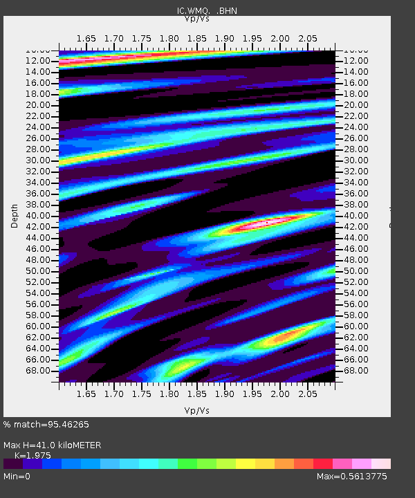
| Estimated Moho Depth: |
41.0 km |
| Estimated Crust Vp/Vs: |
1.98 |
| Assumed Crust Vp: |
6.242 km/s |
| Estimated Crust Vs: |
3.161 km/s |
| Estimated Crust Poisson's Ratio: |
0.33 |
|
| Radial Match: |
95.46265 % |
| Radial Bump: |
249 |
| Transverse Match: |
83.1135 % |
| Transverse Bump: |
400 |
| SOD ConfigId: |
4480 |
| Insert Time: |
2010-03-05 00:18:38.648 +0000 |
| GWidth: |
2.5 |
| Max Bumps: |
400 |
| Tol: |
0.001 |
|
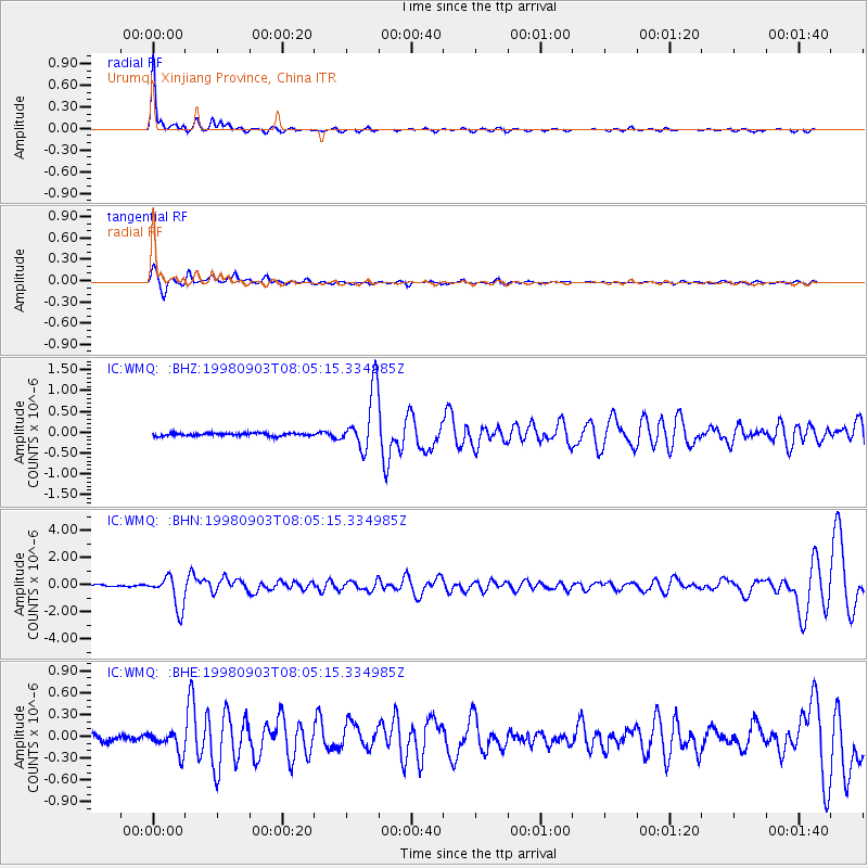
Signal To Noise
| Channel | StoN | STA | LTA |
| IC:WMQ: :BHN:19980903T08:05:15.334985Z | 18.044449 | 1.183447E-6 | 6.55851E-8 |
| IC:WMQ: :BHE:19980903T08:05:15.334985Z | 2.8374913 | 1.4067408E-7 | 4.9576922E-8 |
| IC:WMQ: :BHZ:19980903T08:05:15.334985Z | 21.308727 | 7.219751E-7 | 3.3881662E-8 |
| Arrivals |
| Ps | 6.8 SECOND |
| PpPs | 18 SECOND |
| PsPs/PpSs | 25 SECOND |


