You are here: Home > Network List > TA - USArray Transportable Network (new EarthScope stations) Stations List
> Station 833A Chaparral WMA, Artesia Wells, TX, USA > Earthquake Result Viewer
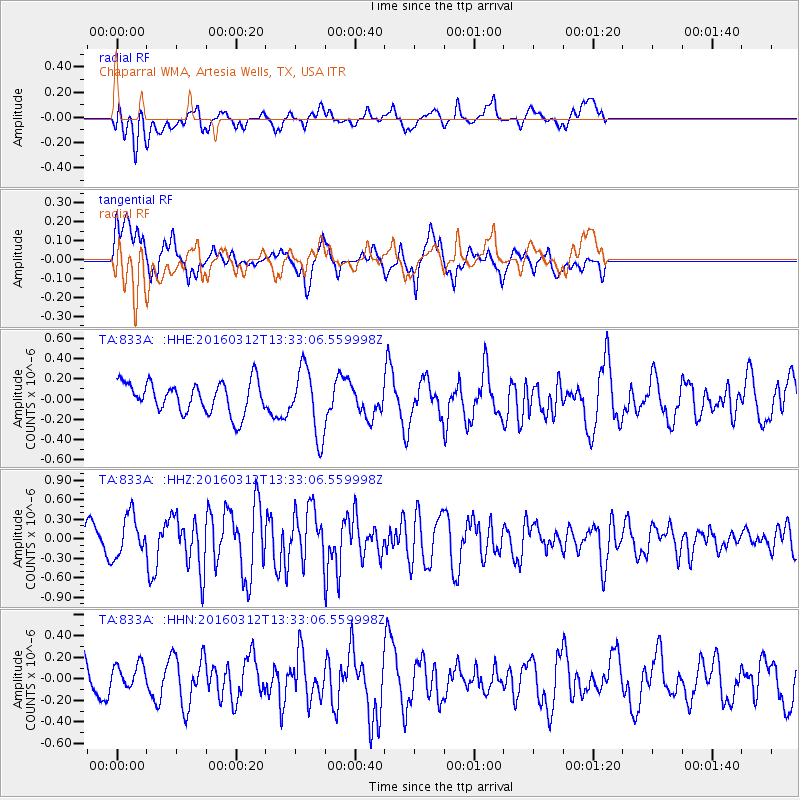
833A Chaparral WMA, Artesia Wells, TX, USA - Earthquake Result Viewer
*The percent match for this event was below the threshold and hence no stack was calculated.
| Earthquake location: |
Andreanof Islands, Aleutian Is. |
| Earthquake latitude/longitude: |
51.4/-174.0 |
| Earthquake time(UTC): |
2016/03/12 (072) 13:23:38 GMT |
| Earthquake Depth: |
13 km |
| Earthquake Magnitude: |
5.6 mww |
| Earthquake Catalog/Contributor: |
NEIC PDE/ |
|
| Network: |
TA USArray Transportable Network (new EarthScope stations) |
| Station: |
833A Chaparral WMA, Artesia Wells, TX, USA |
| Lat/Lon: |
28.32 N/99.39 W |
| Elevation: |
171 m |
|
| Distance: |
59.0 deg |
| Az: |
82.46 deg |
| Baz: |
315.279 deg |
| Ray Param: |
$rayparam |
*The percent match for this event was below the threshold and hence was not used in the summary stack. |
|
| Radial Match: |
53.070244 % |
| Radial Bump: |
400 |
| Transverse Match: |
61.789413 % |
| Transverse Bump: |
400 |
| SOD ConfigId: |
7422571 |
| Insert Time: |
2019-04-22 00:34:41.617 +0000 |
| GWidth: |
2.5 |
| Max Bumps: |
400 |
| Tol: |
0.001 |
|
Signal To Noise
| Channel | StoN | STA | LTA |
| TA:833A: :HHZ:20160312T13:33:06.559998Z | 1.8800532 | 3.1807423E-7 | 1.6918364E-7 |
| TA:833A: :HHN:20160312T13:33:06.559998Z | 0.75364405 | 1.17020484E-7 | 1.5527289E-7 |
| TA:833A: :HHE:20160312T13:33:06.559998Z | 2.1397824 | 3.2739678E-7 | 1.5300469E-7 |
| Arrivals |
| Ps | |
| PpPs | |
| PsPs/PpSs | |


