You are here: Home > Network List > CI - Caltech Regional Seismic Network Stations List
> Station MPM Manuel Prospect Mine, California, USA > Earthquake Result Viewer
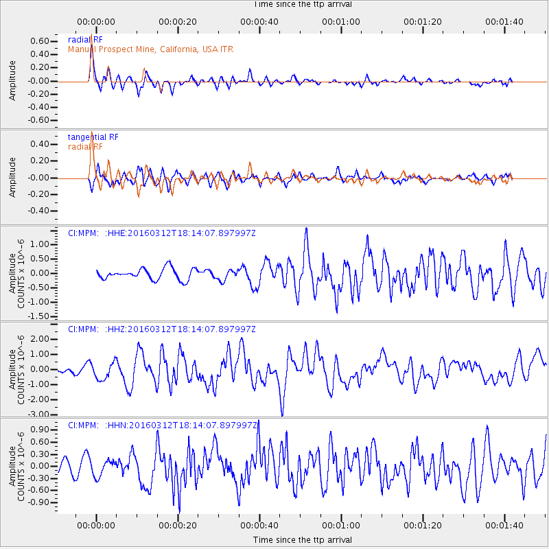
MPM Manuel Prospect Mine, California, USA - Earthquake Result Viewer
*The percent match for this event was below the threshold and hence no stack was calculated.
| Earthquake location: |
Andreanof Islands, Aleutian Is. |
| Earthquake latitude/longitude: |
51.6/-174.0 |
| Earthquake time(UTC): |
2016/03/12 (072) 18:06:45 GMT |
| Earthquake Depth: |
19 km |
| Earthquake Magnitude: |
6.3 MWW, 6.1 MB, 6.2 MWB, 6.3 MWC, 6.4 MWC, 6.4 MI |
| Earthquake Catalog/Contributor: |
NEIC PDE/NEIC COMCAT |
|
| Network: |
CI Caltech Regional Seismic Network |
| Station: |
MPM Manuel Prospect Mine, California, USA |
| Lat/Lon: |
36.06 N/117.49 W |
| Elevation: |
185 m |
|
| Distance: |
42.5 deg |
| Az: |
88.579 deg |
| Baz: |
309.633 deg |
| Ray Param: |
$rayparam |
*The percent match for this event was below the threshold and hence was not used in the summary stack. |
|
| Radial Match: |
76.589264 % |
| Radial Bump: |
400 |
| Transverse Match: |
75.73896 % |
| Transverse Bump: |
400 |
| SOD ConfigId: |
7422571 |
| Insert Time: |
2019-04-22 00:39:19.087 +0000 |
| GWidth: |
2.5 |
| Max Bumps: |
400 |
| Tol: |
0.001 |
|
Signal To Noise
| Channel | StoN | STA | LTA |
| CI:MPM: :HHZ:20160312T18:14:07.897997Z | 1.8129139 | 5.495683E-7 | 3.0314087E-7 |
| CI:MPM: :HHN:20160312T18:14:07.897997Z | 1.1279014 | 2.114371E-7 | 1.874606E-7 |
| CI:MPM: :HHE:20160312T18:14:07.897997Z | 1.0638971 | 2.063333E-7 | 1.9394102E-7 |
| Arrivals |
| Ps | |
| PpPs | |
| PsPs/PpSs | |


