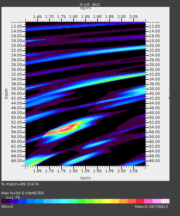
JGF Gifu Kurokawa - Earthquake Result Viewer

Earthquake location: Andreanof Islands, Aleutian Is.
Earthquake latitude/longitude: 51.6/-174.0
Earthquake time(UTC): 2016/03/12 (072) 18:06:45 GMT
Earthquake Depth: 19 km
Earthquake Magnitude: 6.3 MWW, 6.1 MB, 6.2 MWB, 6.3 MWC, 6.4 MWC, 6.4 MI
Earthquake Catalog/Contributor: NEIC PDE/NEIC COMCAT
Network: JP Japan Meteorological Agency Seismic Network
Station: JGF Gifu Kurokawa
Lat/Lon: 35.60 N/137.35 E
Elevation: 580 m
Distance: 37.9 deg
Az: 264.484 deg
Baz: 49.683 deg
Ray Param: 0.075849734
Estimated Moho Depth: 54.5 km
Estimated Crust Vp/Vs: 1.75
Assumed Crust Vp: 6.461 km/s
Estimated Crust Vs: 3.692 km/s
Estimated Crust Poisson's Ratio: 0.26
Radial Match: 99.33478 %
Radial Bump: 127
Transverse Match: 80.751564 %
Transverse Bump: 400
SOD ConfigId: 7422571
Insert Time: 2019-04-22 00:41:14.527 +0000
GWidth: 2.5
Max Bumps: 400
Tol: 0.001

Signal To Noise

ChannelStoNSTALTA
JP:JGF: :BHZ:20160312T18:13:30.349993Z9.6485339.2038516E-79.539121E-8
JP:JGF: :BHN:20160312T18:13:30.349993Z4.89779854.519657E-79.227936E-8
JP:JGF: :BHE:20160312T18:13:30.349993Z6.19251735.207097E-78.408692E-8
Arrivals
Ps6.8 SECOND
PpPs22 SECOND
PsPs/PpSs28 SECOND