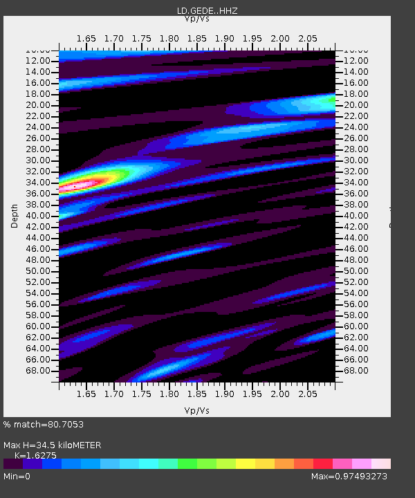
GEDE Greenville, DE, USA - Earthquake Result Viewer
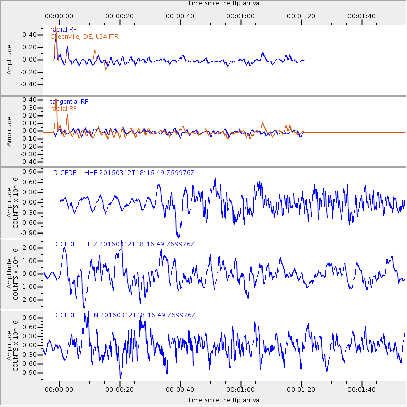
Earthquake location: Andreanof Islands, Aleutian Is.
Earthquake latitude/longitude: 51.6/-174.0
Earthquake time(UTC): 2016/03/12 (072) 18:06:45 GMT
Earthquake Depth: 19 km
Earthquake Magnitude: 6.3 MWW, 6.1 MB, 6.2 MWB, 6.3 MWC, 6.4 MWC, 6.4 MI
Earthquake Catalog/Contributor: NEIC PDE/NEIC COMCAT
Network: LD Lamont-Doherty Cooperative Seismographic Network
Station: GEDE Greenville, DE, USA
Lat/Lon: 39.81 N/75.64 W
Elevation: 105 m
Distance: 64.7 deg
Az: 57.476 deg
Baz: 316.897 deg
Ray Param: 0.058763195
Estimated Moho Depth: 34.5 km
Estimated Crust Vp/Vs: 1.63
Assumed Crust Vp: 6.287 km/s
Estimated Crust Vs: 3.863 km/s
Estimated Crust Poisson's Ratio: 0.20
Radial Match: 80.7053 %
Radial Bump: 400
Transverse Match: 49.197506 %
Transverse Bump: 400
SOD ConfigId: 7422571
Insert Time: 2019-04-22 00:42:02.304 +0000
GWidth: 2.5
Max Bumps: 400
Tol: 0.001

Signal To Noise

ChannelStoNSTALTA
LD:GEDE: :HHZ:20160312T18:16:49.769976Z6.27033331.0767883E-61.7172744E-7
LD:GEDE: :HHN:20160312T18:16:49.769976Z1.25899852.3499193E-71.8664988E-7
LD:GEDE: :HHE:20160312T18:16:49.769976Z2.16416032.825862E-71.3057544E-7
Arrivals
Ps3.6 SECOND
PpPs14 SECOND
PsPs/PpSs17 SECOND