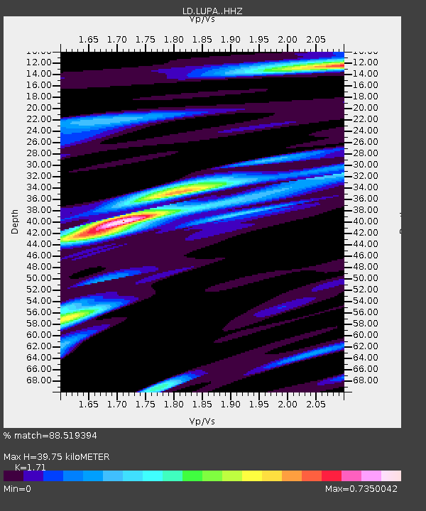
LUPA Lehigh University, PA - Earthquake Result Viewer
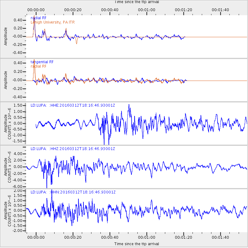
Earthquake location: Andreanof Islands, Aleutian Is.
Earthquake latitude/longitude: 51.6/-174.0
Earthquake time(UTC): 2016/03/12 (072) 18:06:45 GMT
Earthquake Depth: 19 km
Earthquake Magnitude: 6.3 MWW, 6.1 MB, 6.2 MWB, 6.3 MWC, 6.4 MWC, 6.4 MI
Earthquake Catalog/Contributor: NEIC PDE/NEIC COMCAT
Network: LD Lamont-Doherty Cooperative Seismographic Network
Station: LUPA Lehigh University, PA
Lat/Lon: 40.60 N/75.37 W
Elevation: 236 m
Distance: 64.2 deg
Az: 56.716 deg
Baz: 316.739 deg
Ray Param: 0.059041552
Estimated Moho Depth: 39.75 km
Estimated Crust Vp/Vs: 1.71
Assumed Crust Vp: 6.283 km/s
Estimated Crust Vs: 3.674 km/s
Estimated Crust Poisson's Ratio: 0.24
Radial Match: 88.519394 %
Radial Bump: 293
Transverse Match: 60.980232 %
Transverse Bump: 400
SOD ConfigId: 7422571
Insert Time: 2019-04-22 00:42:06.214 +0000
GWidth: 2.5
Max Bumps: 400
Tol: 0.001

Signal To Noise

ChannelStoNSTALTA
LD:LUPA: :HHZ:20160312T18:16:46.93001Z5.2482871.2481705E-62.3782435E-7
LD:LUPA: :HHN:20160312T18:16:46.93001Z2.3439223.432999E-71.4646388E-7
LD:LUPA: :HHE:20160312T18:16:46.93001Z2.17130684.0673345E-71.8732194E-7
Arrivals
Ps4.7 SECOND
PpPs16 SECOND
PsPs/PpSs21 SECOND