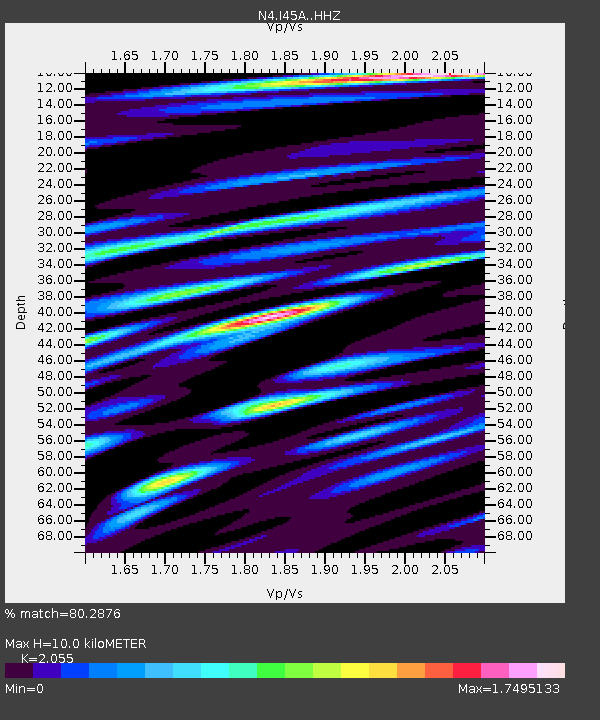
I45A Fountain, MI, USA - Earthquake Result Viewer

Earthquake location: Andreanof Islands, Aleutian Is.
Earthquake latitude/longitude: 51.6/-174.0
Earthquake time(UTC): 2016/03/12 (072) 18:06:45 GMT
Earthquake Depth: 19 km
Earthquake Magnitude: 6.3 MWW, 6.1 MB, 6.2 MWB, 6.3 MWC, 6.4 MWC, 6.4 MI
Earthquake Catalog/Contributor: NEIC PDE/NEIC COMCAT
Network: N4 Central and EAstern US Network
Station: I45A Fountain, MI, USA
Lat/Lon: 44.04 N/86.23 W
Elevation: 215 m
Distance: 56.0 deg
Az: 60.323 deg
Baz: 311.237 deg
Ray Param: 0.06437486
Estimated Moho Depth: 10.0 km
Estimated Crust Vp/Vs: 2.06
Assumed Crust Vp: 6.53 km/s
Estimated Crust Vs: 3.178 km/s
Estimated Crust Poisson's Ratio: 0.34
Radial Match: 80.2876 %
Radial Bump: 400
Transverse Match: 64.306816 %
Transverse Bump: 400
SOD ConfigId: 7422571
Insert Time: 2019-04-22 00:42:56.035 +0000
GWidth: 2.5
Max Bumps: 400
Tol: 0.001

Signal To Noise

ChannelStoNSTALTA
N4:I45A: :HHZ:20160312T18:15:50.990007Z3.83387731.1012397E-62.8723915E-7
N4:I45A: :HHN:20160312T18:15:50.990007Z1.63956554.958369E-73.024197E-7
N4:I45A: :HHE:20160312T18:15:50.990007Z2.4755497.824738E-73.1608093E-7
Arrivals
Ps1.7 SECOND
PpPs4.5 SECOND
PsPs/PpSs6.2 SECOND