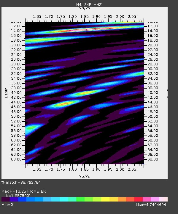
L34B Svendsen Farm, Lyons, NE, USA - Earthquake Result Viewer

Earthquake location: Andreanof Islands, Aleutian Is.
Earthquake latitude/longitude: 51.6/-174.0
Earthquake time(UTC): 2016/03/12 (072) 18:06:45 GMT
Earthquake Depth: 19 km
Earthquake Magnitude: 6.3 MWW, 6.1 MB, 6.2 MWB, 6.3 MWC, 6.4 MWC, 6.4 MI
Earthquake Catalog/Contributor: NEIC PDE/NEIC COMCAT
Network: N4 Central and EAstern US Network
Station: L34B Svendsen Farm, Lyons, NE, USA
Lat/Lon: 41.97 N/96.38 W
Elevation: 414 m
Distance: 51.7 deg
Az: 68.208 deg
Baz: 308.993 deg
Ray Param: 0.06723176
Estimated Moho Depth: 13.25 km
Estimated Crust Vp/Vs: 1.86
Assumed Crust Vp: 6.498 km/s
Estimated Crust Vs: 3.498 km/s
Estimated Crust Poisson's Ratio: 0.30
Radial Match: 88.762764 %
Radial Bump: 400
Transverse Match: 77.42392 %
Transverse Bump: 400
SOD ConfigId: 7422571
Insert Time: 2019-04-22 00:43:12.307 +0000
GWidth: 2.5
Max Bumps: 400
Tol: 0.001

Signal To Noise

ChannelStoNSTALTA
N4:L34B: :HHZ:20160312T18:15:19.089983Z7.5090951.2864834E-61.7132336E-7
N4:L34B: :HHN:20160312T18:15:19.089983Z3.0581858.3458525E-72.7290216E-7
N4:L34B: :HHE:20160312T18:15:19.089983Z5.14165931.3966489E-62.716339E-7
Arrivals
Ps1.8 SECOND
PpPs5.5 SECOND
PsPs/PpSs7.4 SECOND