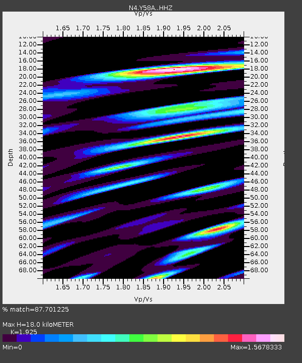
Y58A Scranton, SC, USA - Earthquake Result Viewer

Earthquake location: Andreanof Islands, Aleutian Is.
Earthquake latitude/longitude: 51.6/-174.0
Earthquake time(UTC): 2016/03/12 (072) 18:06:45 GMT
Earthquake Depth: 19 km
Earthquake Magnitude: 6.3 MWW, 6.1 MB, 6.2 MWB, 6.3 MWC, 6.4 MWC, 6.4 MI
Earthquake Catalog/Contributor: NEIC PDE/NEIC COMCAT
Network: N4 Central and EAstern US Network
Station: Y58A Scranton, SC, USA
Lat/Lon: 33.91 N/79.67 W
Elevation: 19 m
Distance: 66.8 deg
Az: 64.474 deg
Baz: 317.367 deg
Ray Param: 0.057371844
Estimated Moho Depth: 18.0 km
Estimated Crust Vp/Vs: 1.92
Assumed Crust Vp: 6.24 km/s
Estimated Crust Vs: 3.242 km/s
Estimated Crust Poisson's Ratio: 0.32
Radial Match: 87.701225 %
Radial Bump: 400
Transverse Match: 67.31831 %
Transverse Bump: 400
SOD ConfigId: 7422571
Insert Time: 2019-04-22 00:44:16.939 +0000
GWidth: 2.5
Max Bumps: 400
Tol: 0.001

Signal To Noise

ChannelStoNSTALTA
N4:Y58A: :HHZ:20160312T18:17:03.40999Z5.21944051.0196786E-61.9536168E-7
N4:Y58A: :HHN:20160312T18:17:03.40999Z1.11934525.8111823E-75.1915913E-7
N4:Y58A: :HHE:20160312T18:17:03.40999Z1.3484674.0124223E-72.9755435E-7
Arrivals
Ps2.8 SECOND
PpPs8.1 SECOND
PsPs/PpSs11 SECOND