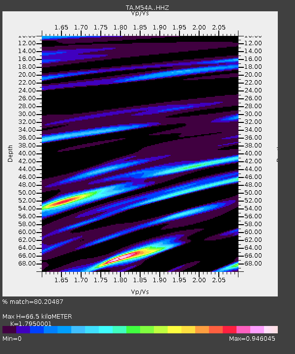
M54A Oil Creek State Park, Oil City, PA, USA - Earthquake Result Viewer

Earthquake location: Andreanof Islands, Aleutian Is.
Earthquake latitude/longitude: 51.6/-174.0
Earthquake time(UTC): 2016/03/12 (072) 18:06:45 GMT
Earthquake Depth: 19 km
Earthquake Magnitude: 6.3 MWW, 6.1 MB, 6.2 MWB, 6.3 MWC, 6.4 MWC, 6.4 MI
Earthquake Catalog/Contributor: NEIC PDE/NEIC COMCAT
Network: TA USArray Transportable Network (new EarthScope stations)
Station: M54A Oil Creek State Park, Oil City, PA, USA
Lat/Lon: 41.51 N/79.66 W
Elevation: 488 m
Distance: 61.3 deg
Az: 58.62 deg
Baz: 314.801 deg
Ray Param: 0.06093812
Estimated Moho Depth: 66.5 km
Estimated Crust Vp/Vs: 1.80
Assumed Crust Vp: 6.121 km/s
Estimated Crust Vs: 3.41 km/s
Estimated Crust Poisson's Ratio: 0.27
Radial Match: 80.20487 %
Radial Bump: 355
Transverse Match: 57.76214 %
Transverse Bump: 400
SOD ConfigId: 7422571
Insert Time: 2019-04-22 00:46:28.996 +0000
GWidth: 2.5
Max Bumps: 400
Tol: 0.001

Signal To Noise

ChannelStoNSTALTA
TA:M54A: :HHZ:20160312T18:16:27.529985Z4.7861731.0802278E-62.256976E-7
TA:M54A: :HHN:20160312T18:16:27.529985Z3.1133985.401959E-71.7350685E-7
TA:M54A: :HHE:20160312T18:16:27.529985Z3.28577265.799866E-71.7651453E-7
Arrivals
Ps9.0 SECOND
PpPs29 SECOND
PsPs/PpSs38 SECOND