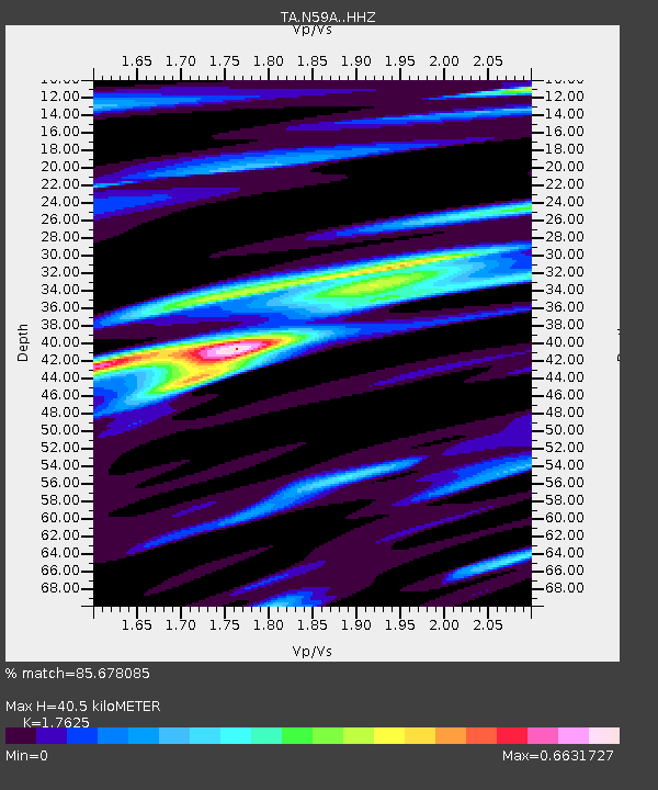
N59A State Game Land 141, Hazleton, PA, USA - Earthquake Result Viewer
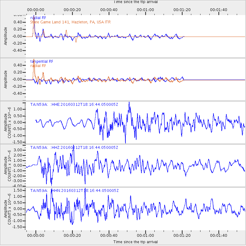
Earthquake location: Andreanof Islands, Aleutian Is.
Earthquake latitude/longitude: 51.6/-174.0
Earthquake time(UTC): 2016/03/12 (072) 18:06:45 GMT
Earthquake Depth: 19 km
Earthquake Magnitude: 6.3 MWW, 6.1 MB, 6.2 MWB, 6.3 MWC, 6.4 MWC, 6.4 MI
Earthquake Catalog/Contributor: NEIC PDE/NEIC COMCAT
Network: TA USArray Transportable Network (new EarthScope stations)
Station: N59A State Game Land 141, Hazleton, PA, USA
Lat/Lon: 40.92 N/75.77 W
Elevation: 508 m
Distance: 63.8 deg
Az: 56.718 deg
Baz: 316.48 deg
Ray Param: 0.059332833
Estimated Moho Depth: 40.5 km
Estimated Crust Vp/Vs: 1.76
Assumed Crust Vp: 6.283 km/s
Estimated Crust Vs: 3.565 km/s
Estimated Crust Poisson's Ratio: 0.26
Radial Match: 85.678085 %
Radial Bump: 341
Transverse Match: 64.04991 %
Transverse Bump: 400
SOD ConfigId: 7422571
Insert Time: 2019-04-22 00:46:31.336 +0000
GWidth: 2.5
Max Bumps: 400
Tol: 0.001

Signal To Noise

ChannelStoNSTALTA
TA:N59A: :HHZ:20160312T18:16:44.050005Z5.03775931.0025192E-61.9900102E-7
TA:N59A: :HHN:20160312T18:16:44.050005Z2.06878733.9725003E-71.920207E-7
TA:N59A: :HHE:20160312T18:16:44.050005Z2.58340365.10099E-71.9745234E-7
Arrivals
Ps5.1 SECOND
PpPs17 SECOND
PsPs/PpSs22 SECOND