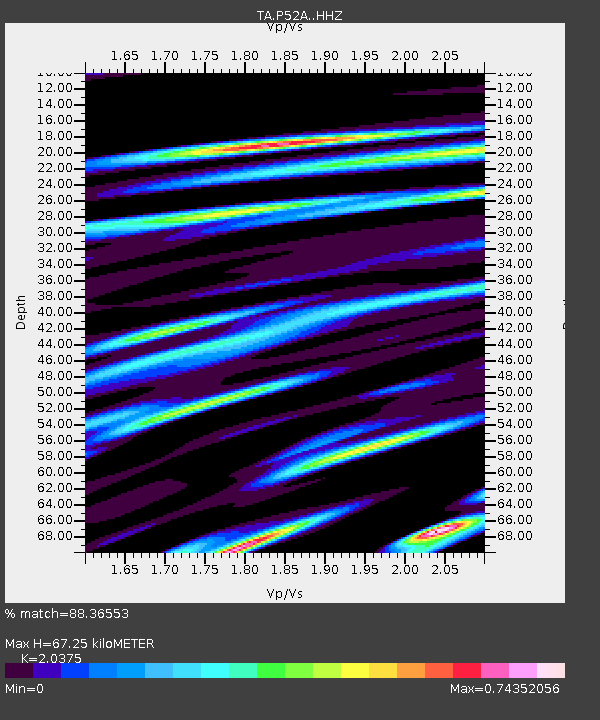
P52A Corning, OH, USA - Earthquake Result Viewer

Earthquake location: Andreanof Islands, Aleutian Is.
Earthquake latitude/longitude: 51.6/-174.0
Earthquake time(UTC): 2016/03/12 (072) 18:06:45 GMT
Earthquake Depth: 19 km
Earthquake Magnitude: 6.3 MWW, 6.1 MB, 6.2 MWB, 6.3 MWC, 6.4 MWC, 6.4 MI
Earthquake Catalog/Contributor: NEIC PDE/NEIC COMCAT
Network: TA USArray Transportable Network (new EarthScope stations)
Station: P52A Corning, OH, USA
Lat/Lon: 39.63 N/82.13 W
Elevation: 293 m
Distance: 61.3 deg
Az: 61.645 deg
Baz: 314.654 deg
Ray Param: 0.06095021
Estimated Moho Depth: 67.25 km
Estimated Crust Vp/Vs: 2.04
Assumed Crust Vp: 6.232 km/s
Estimated Crust Vs: 3.058 km/s
Estimated Crust Poisson's Ratio: 0.34
Radial Match: 88.36553 %
Radial Bump: 342
Transverse Match: 62.5904 %
Transverse Bump: 400
SOD ConfigId: 7422571
Insert Time: 2019-04-22 00:46:35.937 +0000
GWidth: 2.5
Max Bumps: 400
Tol: 0.001

Signal To Noise

ChannelStoNSTALTA
TA:P52A: :HHZ:20160312T18:16:27.39998Z3.41444598.8018993E-72.577841E-7
TA:P52A: :HHN:20160312T18:16:27.39998Z1.94052682.749308E-71.4167843E-7
TA:P52A: :HHE:20160312T18:16:27.39998Z1.45006542.6363563E-71.8180948E-7
Arrivals
Ps12 SECOND
PpPs32 SECOND
PsPs/PpSs43 SECOND