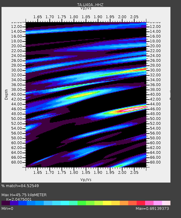
U40A Yellville, AR, USA - Earthquake Result Viewer

Earthquake location: Andreanof Islands, Aleutian Is.
Earthquake latitude/longitude: 51.6/-174.0
Earthquake time(UTC): 2016/03/12 (072) 18:06:45 GMT
Earthquake Depth: 19 km
Earthquake Magnitude: 6.3 MWW, 6.1 MB, 6.2 MWB, 6.3 MWC, 6.4 MWC, 6.4 MI
Earthquake Catalog/Contributor: NEIC PDE/NEIC COMCAT
Network: TA USArray Transportable Network (new EarthScope stations)
Station: U40A Yellville, AR, USA
Lat/Lon: 36.36 N/92.85 W
Elevation: 374 m
Distance: 57.4 deg
Az: 71.193 deg
Baz: 312.945 deg
Ray Param: 0.06347941
Estimated Moho Depth: 45.75 km
Estimated Crust Vp/Vs: 2.05
Assumed Crust Vp: 6.53 km/s
Estimated Crust Vs: 3.189 km/s
Estimated Crust Poisson's Ratio: 0.34
Radial Match: 84.52549 %
Radial Bump: 333
Transverse Match: 62.757725 %
Transverse Bump: 400
SOD ConfigId: 7422571
Insert Time: 2019-04-22 00:46:41.388 +0000
GWidth: 2.5
Max Bumps: 400
Tol: 0.001

Signal To Noise

ChannelStoNSTALTA
TA:U40A: :HHZ:20160312T18:16:00.719988Z5.36571655.121077E-79.54407E-8
TA:U40A: :HHN:20160312T18:16:00.719988Z2.40521931.7979339E-77.475135E-8
TA:U40A: :HHE:20160312T18:16:00.719988Z2.58181212.4262377E-79.397421E-8
Arrivals
Ps7.7 SECOND
PpPs20 SECOND
PsPs/PpSs28 SECOND