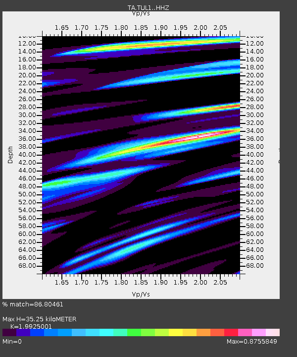
TUL1 Leonard, OK, USA - Earthquake Result Viewer
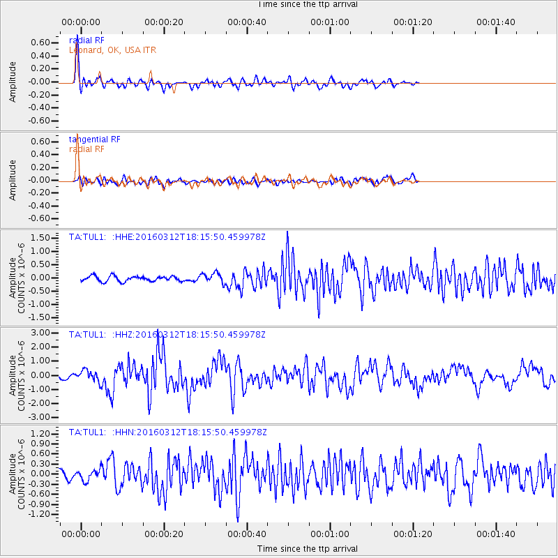
Earthquake location: Andreanof Islands, Aleutian Is.
Earthquake latitude/longitude: 51.6/-174.0
Earthquake time(UTC): 2016/03/12 (072) 18:06:45 GMT
Earthquake Depth: 19 km
Earthquake Magnitude: 6.3 MWW, 6.1 MB, 6.2 MWB, 6.3 MWC, 6.4 MWC, 6.4 MI
Earthquake Catalog/Contributor: NEIC PDE/NEIC COMCAT
Network: TA USArray Transportable Network (new EarthScope stations)
Station: TUL1 Leonard, OK, USA
Lat/Lon: 35.91 N/95.79 W
Elevation: 256 m
Distance: 56.0 deg
Az: 73.514 deg
Baz: 312.495 deg
Ray Param: 0.06442048
Estimated Moho Depth: 35.25 km
Estimated Crust Vp/Vs: 1.99
Assumed Crust Vp: 6.498 km/s
Estimated Crust Vs: 3.261 km/s
Estimated Crust Poisson's Ratio: 0.33
Radial Match: 86.80461 %
Radial Bump: 365
Transverse Match: 72.53977 %
Transverse Bump: 400
SOD ConfigId: 7422571
Insert Time: 2019-04-22 00:46:41.386 +0000
GWidth: 2.5
Max Bumps: 400
Tol: 0.001

Signal To Noise

ChannelStoNSTALTA
TA:TUL1: :HHZ:20160312T18:15:50.459978Z4.03906544.0633282E-71.006007E-7
TA:TUL1: :HHN:20160312T18:15:50.459978Z1.2446451.6312815E-71.3106398E-7
TA:TUL1: :HHE:20160312T18:15:50.459978Z2.3032692.2864147E-79.926824E-8
Arrivals
Ps5.6 SECOND
PpPs15 SECOND
PsPs/PpSs21 SECOND