W41B Gary Mavity, Velonia, AR, USA - Earthquake Result Viewer
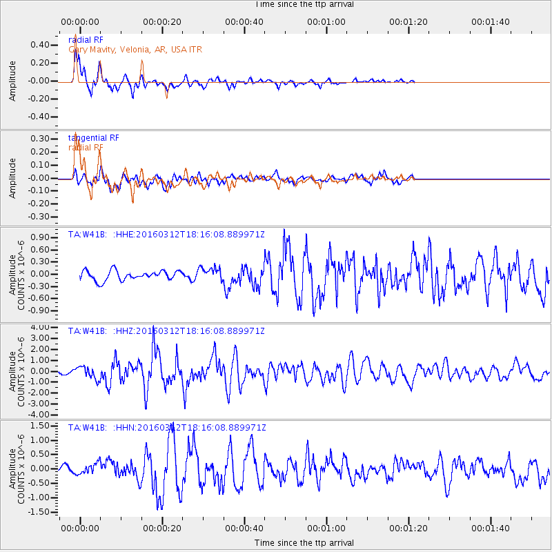
Earthquake location: Andreanof Islands, Aleutian Is.
Earthquake latitude/longitude: 51.6/-174.0
Earthquake time(UTC): 2016/03/12 (072) 18:06:45 GMT
Earthquake Depth: 19 km
Earthquake Magnitude: 6.3 MWW, 6.1 MB, 6.2 MWB, 6.3 MWC, 6.4 MWC, 6.4 MI
Earthquake Catalog/Contributor: NEIC PDE/NEIC COMCAT
Network: TA USArray Transportable Network (new EarthScope stations)
Station: W41B Gary Mavity, Velonia, AR, USA
Lat/Lon: 35.17 N/92.25 W
Elevation: 95 m
Distance: 58.6 deg
Az: 71.807 deg
Baz: 313.623 deg
Ray Param: 0.062723845
Estimated Moho Depth: 36.5 km
Estimated Crust Vp/Vs: 2.02
Assumed Crust Vp: 6.498 km/s
Estimated Crust Vs: 3.217 km/s
Estimated Crust Poisson's Ratio: 0.34
Radial Match: 88.24493 %
Radial Bump: 400
Transverse Match: 76.21744 %
Transverse Bump: 400
SOD ConfigId: 7422571
Insert Time: 2019-04-22 00:46:44.718 +0000
GWidth: 2.5
Max Bumps: 400
Tol: 0.001

Signal To Noise

ChannelStoNSTALTA
TA:W41B: :HHZ:20160312T18:16:08.889971Z3.6665735.800563E-71.582012E-7
TA:W41B: :HHN:20160312T18:16:08.889971Z1.31051172.2200174E-71.694008E-7
TA:W41B: :HHE:20160312T18:16:08.889971Z1.8892852.2055323E-71.16738995E-7
Arrivals
Ps6.0 SECOND
PpPs16 SECOND
PsPs/PpSs22 SECOND