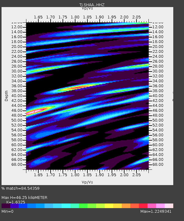
SHAA Shaartuz, Tajikistan - Earthquake Result Viewer
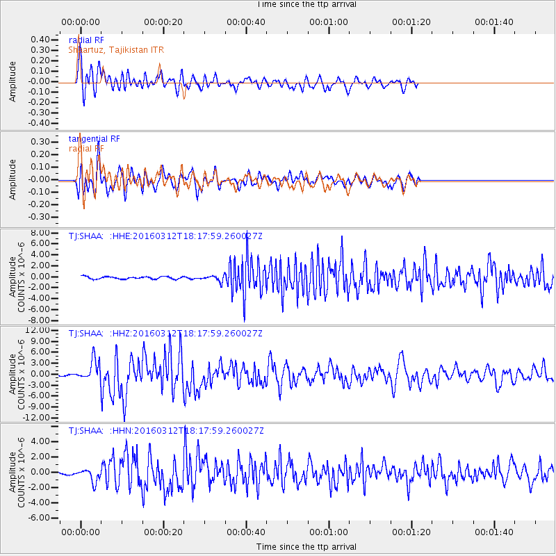
Earthquake location: Andreanof Islands, Aleutian Is.
Earthquake latitude/longitude: 51.6/-174.0
Earthquake time(UTC): 2016/03/12 (072) 18:06:45 GMT
Earthquake Depth: 19 km
Earthquake Magnitude: 6.3 MWW, 6.1 MB, 6.2 MWB, 6.3 MWC, 6.4 MWC, 6.4 MI
Earthquake Catalog/Contributor: NEIC PDE/NEIC COMCAT
Network: TJ Tajikistan National Seismic Network
Station: SHAA Shaartuz, Tajikistan
Lat/Lon: 37.56 N/68.12 E
Elevation: 868 m
Distance: 76.0 deg
Az: 313.594 deg
Baz: 34.674 deg
Ray Param: 0.051295426
Estimated Moho Depth: 46.25 km
Estimated Crust Vp/Vs: 1.63
Assumed Crust Vp: 6.213 km/s
Estimated Crust Vs: 3.806 km/s
Estimated Crust Poisson's Ratio: 0.20
Radial Match: 84.54359 %
Radial Bump: 400
Transverse Match: 83.2529 %
Transverse Bump: 400
SOD ConfigId: 7422571
Insert Time: 2019-04-22 00:46:55.952 +0000
GWidth: 2.5
Max Bumps: 400
Tol: 0.001

Signal To Noise

ChannelStoNSTALTA
TJ:SHAA: :HHZ:20160312T18:17:59.260027Z21.146293.0142028E-61.425405E-7
TJ:SHAA: :HHN:20160312T18:17:59.260027Z3.2738348.7401065E-72.6696856E-7
TJ:SHAA: :HHE:20160312T18:17:59.260027Z2.78374626.0169157E-72.1614454E-7
Arrivals
Ps4.9 SECOND
PpPs19 SECOND
PsPs/PpSs24 SECOND