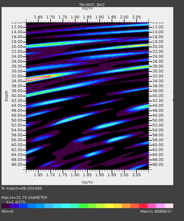
MHIT MHIT Phase1 - Earthquake Result Viewer

Earthquake location: Andreanof Islands, Aleutian Is.
Earthquake latitude/longitude: 51.6/-174.0
Earthquake time(UTC): 2016/03/12 (072) 18:06:45 GMT
Earthquake Depth: 19 km
Earthquake Magnitude: 6.3 MWW, 6.1 MB, 6.2 MWB, 6.3 MWC, 6.4 MWC, 6.4 MI
Earthquake Catalog/Contributor: NEIC PDE/NEIC COMCAT
Network: TM Thai Seismic Monitoring Network
Station: MHIT MHIT Phase1
Lat/Lon: 19.31 N/97.96 E
Elevation: 270 m
Distance: 73.9 deg
Az: 280.775 deg
Baz: 40.491 deg
Ray Param: 0.052678328
Estimated Moho Depth: 32.75 km
Estimated Crust Vp/Vs: 1.64
Assumed Crust Vp: 6.316 km/s
Estimated Crust Vs: 3.857 km/s
Estimated Crust Poisson's Ratio: 0.20
Radial Match: 86.000465 %
Radial Bump: 400
Transverse Match: 91.52155 %
Transverse Bump: 394
SOD ConfigId: 7422571
Insert Time: 2019-04-22 00:46:58.974 +0000
GWidth: 2.5
Max Bumps: 400
Tol: 0.001

Signal To Noise

ChannelStoNSTALTA
TM:MHIT: :BHZ:20160312T18:17:47.450029Z8.3040917.446995E-78.967862E-8
TM:MHIT: :BHN:20160312T18:17:47.450029Z6.4038076.201849E-79.684628E-8
TM:MHIT: :BHE:20160312T18:17:47.450029Z0.920673676.123435E-86.6510374E-8
Arrivals
Ps3.4 SECOND
PpPs13 SECOND
PsPs/PpSs17 SECOND