You are here: Home > Network List > IC - New China Digital Seismograph Network Stations List
> Station WMQ Urumqi, Xinjiang Province, China > Earthquake Result Viewer
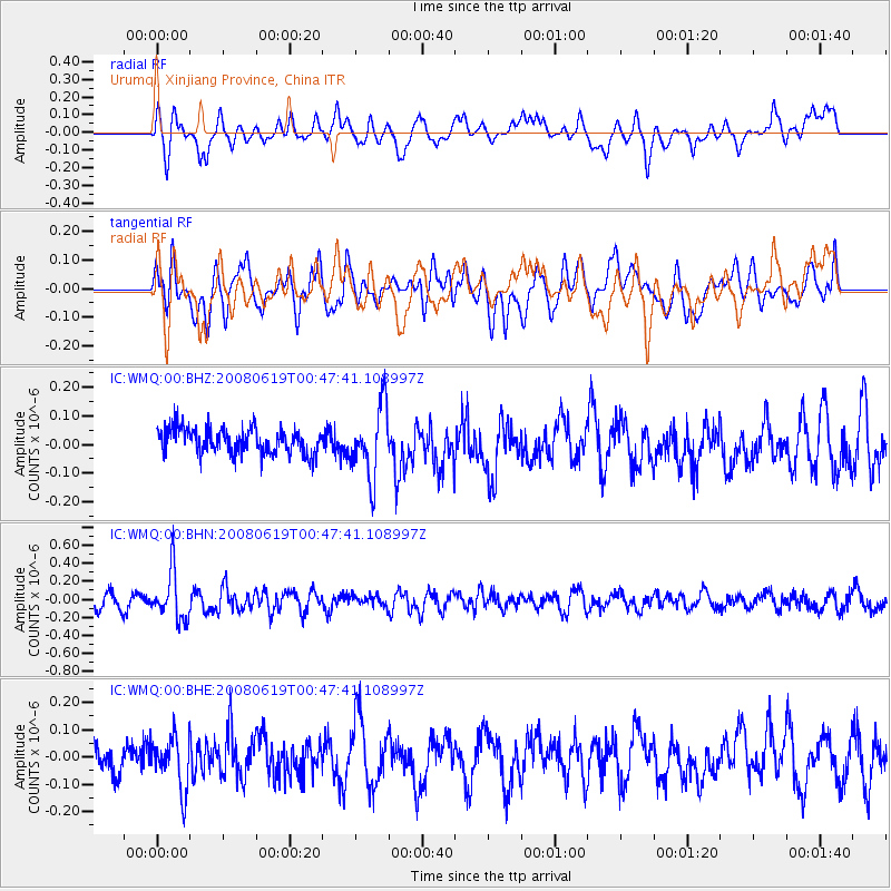
WMQ Urumqi, Xinjiang Province, China - Earthquake Result Viewer
*The percent match for this event was below the threshold and hence no stack was calculated.
| Earthquake location: |
New Britain Region, P.N.G. |
| Earthquake latitude/longitude: |
-4.9/151.8 |
| Earthquake time(UTC): |
2008/06/19 (171) 00:36:45 GMT |
| Earthquake Depth: |
143 km |
| Earthquake Magnitude: |
5.5 MW, 5.2 MB, 5.4 MW |
| Earthquake Catalog/Contributor: |
WHDF/NEIC |
|
| Network: |
IC New China Digital Seismograph Network |
| Station: |
WMQ Urumqi, Xinjiang Province, China |
| Lat/Lon: |
43.82 N/87.69 E |
| Elevation: |
903 m |
|
| Distance: |
75.1 deg |
| Az: |
317.667 deg |
| Baz: |
112.03 deg |
| Ray Param: |
$rayparam |
*The percent match for this event was below the threshold and hence was not used in the summary stack. |
|
| Radial Match: |
59.574493 % |
| Radial Bump: |
400 |
| Transverse Match: |
42.81406 % |
| Transverse Bump: |
400 |
| SOD ConfigId: |
2504 |
| Insert Time: |
2010-03-05 00:24:45.493 +0000 |
| GWidth: |
2.5 |
| Max Bumps: |
400 |
| Tol: |
0.001 |
|
Signal To Noise
| Channel | StoN | STA | LTA |
| IC:WMQ:00:BHN:20080619T00:47:41.108997Z | 3.873753 | 2.68793E-7 | 6.9388264E-8 |
| IC:WMQ:00:BHE:20080619T00:47:41.108997Z | 1.8611466 | 9.5764186E-8 | 5.1454403E-8 |
| IC:WMQ:00:BHZ:20080619T00:47:41.108997Z | 2.7524252 | 1.2408232E-7 | 4.5081087E-8 |
| Arrivals |
| Ps | |
| PpPs | |
| PsPs/PpSs | |


