You are here: Home > Network List > TA - USArray Transportable Network (new EarthScope stations) Stations List
> Station J25K Salcha River, AK, USA > Earthquake Result Viewer
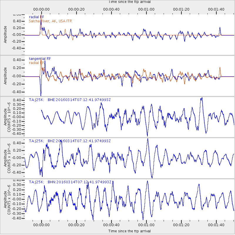
J25K Salcha River, AK, USA - Earthquake Result Viewer
*The percent match for this event was below the threshold and hence no stack was calculated.
| Earthquake location: |
Northwest Of Ryukyu Islands |
| Earthquake latitude/longitude: |
29.8/129.0 |
| Earthquake time(UTC): |
2016/03/14 (074) 07:03:17 GMT |
| Earthquake Depth: |
208 km |
| Earthquake Magnitude: |
5.5 MB |
| Earthquake Catalog/Contributor: |
NEIC PDE/NEIC COMCAT |
|
| Network: |
TA USArray Transportable Network (new EarthScope stations) |
| Station: |
J25K Salcha River, AK, USA |
| Lat/Lon: |
64.61 N/145.37 W |
| Elevation: |
949 m |
|
| Distance: |
61.6 deg |
| Az: |
29.244 deg |
| Baz: |
280.08 deg |
| Ray Param: |
$rayparam |
*The percent match for this event was below the threshold and hence was not used in the summary stack. |
|
| Radial Match: |
65.00861 % |
| Radial Bump: |
400 |
| Transverse Match: |
44.257168 % |
| Transverse Bump: |
400 |
| SOD ConfigId: |
7422571 |
| Insert Time: |
2019-04-22 00:54:20.935 +0000 |
| GWidth: |
2.5 |
| Max Bumps: |
400 |
| Tol: |
0.001 |
|
Signal To Noise
| Channel | StoN | STA | LTA |
| TA:J25K: :BHZ:20160314T07:12:41.974993Z | 2.6495652 | 2.82726E-7 | 1.0670657E-7 |
| TA:J25K: :BHN:20160314T07:12:41.974993Z | 0.8326212 | 1.508863E-7 | 1.812184E-7 |
| TA:J25K: :BHE:20160314T07:12:41.974993Z | 1.8483022 | 2.060055E-7 | 1.1145661E-7 |
| Arrivals |
| Ps | |
| PpPs | |
| PsPs/PpSs | |


