You are here: Home > Network List > TA - USArray Transportable Network (new EarthScope stations) Stations List
> Station MDND Maddock, ND, USA > Earthquake Result Viewer
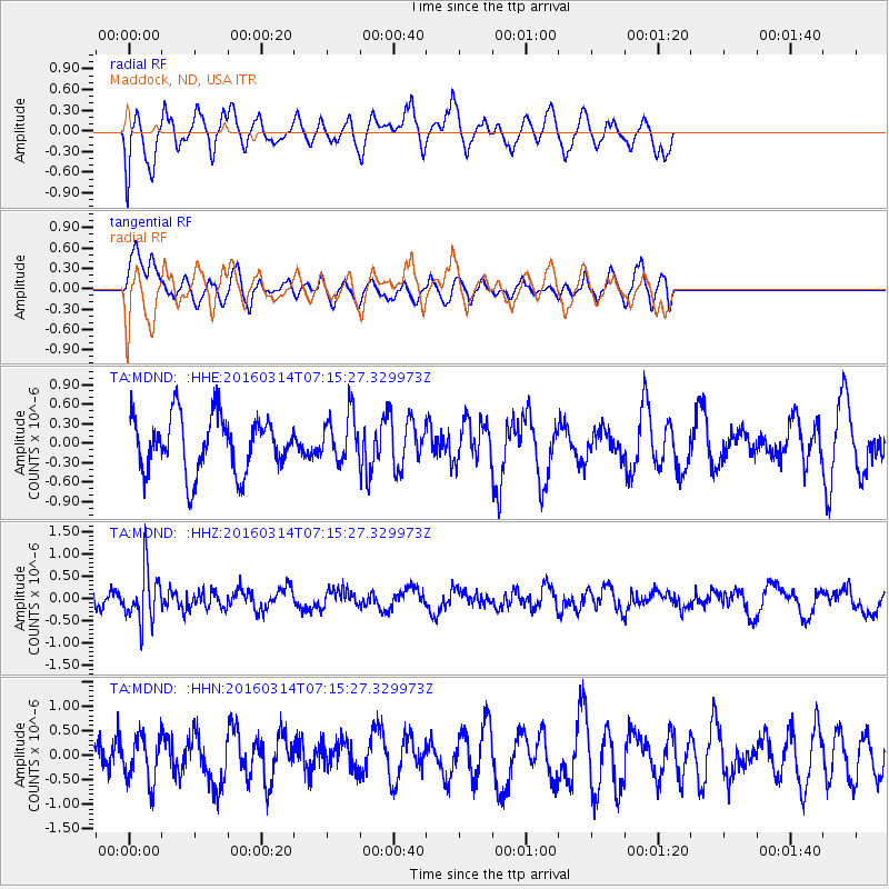
MDND Maddock, ND, USA - Earthquake Result Viewer
*The percent match for this event was below the threshold and hence no stack was calculated.
| Earthquake location: |
Northwest Of Ryukyu Islands |
| Earthquake latitude/longitude: |
29.8/129.0 |
| Earthquake time(UTC): |
2016/03/14 (074) 07:03:17 GMT |
| Earthquake Depth: |
208 km |
| Earthquake Magnitude: |
5.5 MB |
| Earthquake Catalog/Contributor: |
NEIC PDE/NEIC COMCAT |
|
| Network: |
TA USArray Transportable Network (new EarthScope stations) |
| Station: |
MDND Maddock, ND, USA |
| Lat/Lon: |
47.85 N/99.60 W |
| Elevation: |
479 m |
|
| Distance: |
91.2 deg |
| Az: |
30.348 deg |
| Baz: |
319.332 deg |
| Ray Param: |
$rayparam |
*The percent match for this event was below the threshold and hence was not used in the summary stack. |
|
| Radial Match: |
54.29723 % |
| Radial Bump: |
400 |
| Transverse Match: |
56.33086 % |
| Transverse Bump: |
400 |
| SOD ConfigId: |
7422571 |
| Insert Time: |
2019-04-22 00:54:29.250 +0000 |
| GWidth: |
2.5 |
| Max Bumps: |
400 |
| Tol: |
0.001 |
|
Signal To Noise
| Channel | StoN | STA | LTA |
| TA:MDND: :HHZ:20160314T07:15:27.329973Z | 2.7854967 | 5.7516127E-7 | 2.0648427E-7 |
| TA:MDND: :HHN:20160314T07:15:27.329973Z | 0.9064472 | 4.7419124E-7 | 5.231317E-7 |
| TA:MDND: :HHE:20160314T07:15:27.329973Z | 0.9006083 | 3.8538494E-7 | 4.279163E-7 |
| Arrivals |
| Ps | |
| PpPs | |
| PsPs/PpSs | |


