You are here: Home > Network List > CI - Caltech Regional Seismic Network Stations List
> Station BAR Barrett, Tecate, CA, USA > Earthquake Result Viewer
BAR Barrett, Tecate, CA, USA - Earthquake Result Viewer
| Earthquake location: |
Near Coast Of Peru |
| Earthquake latitude/longitude: |
-13.3/-76.5 |
| Earthquake time(UTC): |
2007/08/16 (228) 00:02:41 GMT |
| Earthquake Depth: |
40 km |
| Earthquake Magnitude: |
5.6 MB |
| Earthquake Catalog/Contributor: |
WHDF/NEIC |
|
| Network: |
CI Caltech Regional Seismic Network |
| Station: |
BAR Barrett, Tecate, CA, USA |
| Lat/Lon: |
32.68 N/116.67 W |
| Elevation: |
521 m |
|
| Distance: |
59.7 deg |
| Az: |
320.919 deg |
| Baz: |
133.293 deg |
| Ray Param: |
0.061955553 |
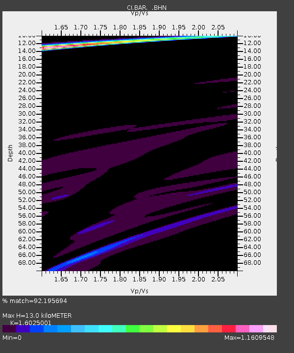
| Estimated Moho Depth: |
13.0 km |
| Estimated Crust Vp/Vs: |
1.60 |
| Assumed Crust Vp: |
6.264 km/s |
| Estimated Crust Vs: |
3.909 km/s |
| Estimated Crust Poisson's Ratio: |
0.18 |
|
| Radial Match: |
92.195694 % |
| Radial Bump: |
400 |
| Transverse Match: |
74.645874 % |
| Transverse Bump: |
214 |
| SOD ConfigId: |
2564 |
| Insert Time: |
2010-02-26 00:09:39.407 +0000 |
| GWidth: |
2.5 |
| Max Bumps: |
400 |
| Tol: |
0.001 |
|
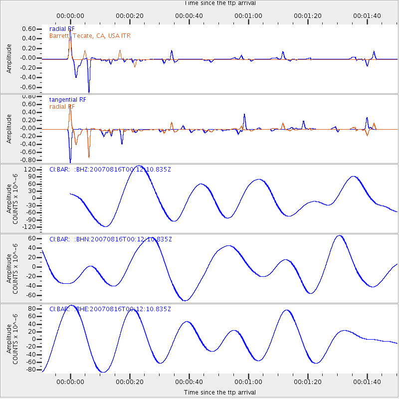
Signal To Noise
| Channel | StoN | STA | LTA |
| CI:BAR: :BHN:20070816T00:12:10.835Z | 0.6193662 | 3.286219E-5 | 5.3057767E-5 |
| CI:BAR: :BHE:20070816T00:12:10.835Z | 1.9800428 | 8.82743E-5 | 4.458202E-5 |
| CI:BAR: :BHZ:20070816T00:12:10.835Z | 0.6710341 | 5.614243E-5 | 8.3665545E-5 |
| Arrivals |
| Ps | 1.3 SECOND |
| PpPs | 5.1 SECOND |
| PsPs/PpSs | 6.5 SECOND |


